Dettagli
Anno di pubblicazione
1708
Luogo di stampa
Amsterdam
Incisori
CHATELAIN Henri Abraham
Descrizione
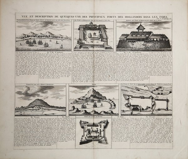
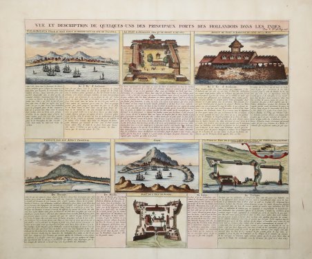
Interessante incisione con sette vedute dettagliate che illustrano gli avamposti commerciali olandesi più importanti e i possedimenti coloniali fortificati nelle Indie Orientali, tra cui 4 vedute del porto di Batavia (Jakarta), Amboina, Ternate e Solor e 3 piani di fortezze, con testo descrittivo in francese. Henri Abraham Chatelain (1684 - 1743) era un pastore ugonotto di origini parigine. È meglio conosciuto come cartografo olandese e più specificamente per il suo contributo cartografico nell’Atlas Historique ' in sette volumi, pubblicato ad Amsterdam tra il 1705 e il 1720. Innovativo per il suo tempo, l'Atlas Historique ' combinava incisioni e opere d'arte con studi di geografia, storia, etnologia, araldica e cosmografia. Alcuni studiosi suggeriscono che l'Atlas Historique ' non fu compilato esclusivamente da Henri Chatelain, come si crede comunemente, ma piuttosto fu un'impresa familiare che coinvolse Henri, suo padre Zacharie e suo fratello, sempre Zacharie. Acquaforte finemente colorata a mano, in ottimo stato di conservazione. Interesting sheet with seven detailed views illustrating the most important Dutch trading outposts and fortified colonial possessions in the East Indies, including 4 harbor views Batavia (Jakarta), Amboina, Ternate, and Solor, and 3 fort plans, with descriptive French text. Features the principal forts of the Dutch in the Indies in the early eighteenth century. Seven precisely detailed vignettes portray the important endeavors and accomplishments following the founding of the Dutch East Indies Company in the early seventeenth century. European frigates and local seagoing vessels embellish the seas. ' Taken from Atlas Historique, published in Amsterdam between 1705 and 1720. Henri Abraham Chatelain (1684 - 1743) was a Huguenot pastor of Parisian origins. He is best known as a Dutch cartographer and more specifically for his cartographic contribution in the seminal seven volume ' Atlas Historique, published in Amsterdam between 1705 and 1720. Innovative for its time, the ' Atlas Historique ' combined fine engraving and artwork with scholarly studies of geography, history, ethnology, heraldry, and cosmography. Some scholarship suggests that the ' Atlas Historique ' was not exclusively compiled by Henri Chatelain, as is commonly believed, but rather was a family enterprise involving Henri, his father Zacharie and his brother, also Zacharie. Copper engraving, with fine later hand colour, ' in excellent condition. Cfr.

 Scopri come utilizzare
 Scopri come utilizzare