Tunetis Urbis ac novae eius arcis, et Guletae…effigies
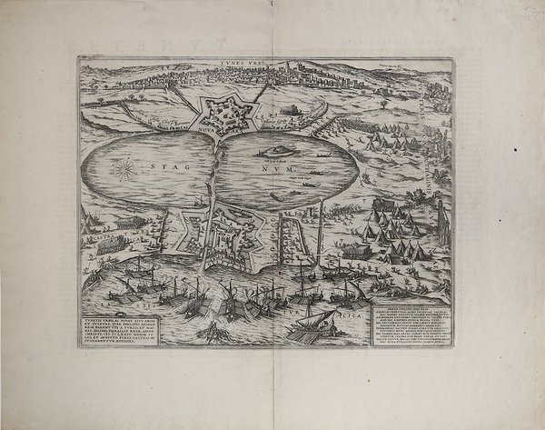
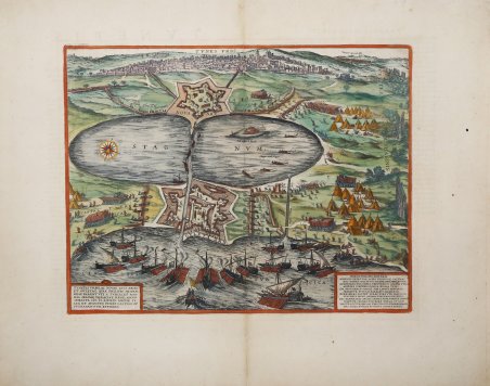
Tunetis Urbis ac novae eius arcis, et Guletae…effigies
Metodi di Pagamento
- PayPal
- Carta di Credito
- Bonifico Bancario
- Pubblica amministrazione
- Carta del Docente
Dettagli
- Anno di pubblicazione
- 1652
- Luogo di stampa
- Amsterdam
- Formato
- 420 X 325
- Incisori
- JANSSONIUS Johannes
- Lingue
- Italiano
Descrizione
Veduta dell'antica città di Tunisi, pubblicata – per la prima volta - nel ' Civitates Orbis Terrarum, di Braun & Hogenberg, il primo atlante devoto esclusivamente alle piante e vedute delle principali città del mondo, stampato in sei volumi tra il 1572 ed il 1617, ebbe grande fortuna e diffusione, tanto che ne furono stampate diverse edizioni tradotte in latino, tedesco e francese; gli intagli dei rami sono attribuiti a Franz Hogenberg e Simon van de Noevel. Il soggetto deriva da un foglio d'occasione del 1573 stampato a Roma da Antonio Lafreri. La città è raffigurata sotto assedio: la città è vista da est, così come il Golfo di Tunisi, con la grande laguna stagnante (stagnum), oggi El Bahira, di fronte. Ai due accessi al mare si trovano le fortezze La ' Goulette e Nova Arx; la città si vede sullo sfondo. Tunisi, fondata prima del IX secolo aC, era sempre stata ambita dalle varie potenze per la sua posizione. Storicamente governata dagli Africani prima e dagli Arabi poi, solo nel 1535 passò sotto il dominio europeo, quando Carlo V riuscì a conseguire una vittoria importante sull'impero ottomano. Nel 1569 i Turchi conquistarono Tunisi sotto Kilic Ali Pasha, la persero nel 1573 contro Filippo II di Spagna per riottenerla nel 1574. Opera ' tratta dal "Theatrum praecipuarum urbium" celebre teatro delle città del Janssonius, sullo stile del "Civitates Orbis Terrarum" di Braun & Hogenberg. La raccolta, pubblicata ad Amsterdam tra il 1652 ed il 1657, contiene 500 tavole raffiguranti città di ogni parte del mondo. Contrariamente al lavoro degli acerrimi rivali Blaeu, Janssonius si servì per la realizzazione dell'opera delle lastre di precedenti cartografi ed editori. In particolare, nel 1653 egli acquisto da Abraham Hogenberg le lastre del "Civitates orbis Terrarum" che incorporò nella sua opera, ristampandole, con alcune modifiche. Per le piante delle città olandesi, ordinò delle nuove lastre basate sull'atlante che Johannes Blaeu diede alla luce nel 1649. Per molte delle opere contenute nel 5° volume, quello dedicato all'Italia e denominato "Theatrum celebriorum urbium Italiae", si servì delle lastre realizzate da Jodocus Hondius per l'opera "Italia Hodierna" del 1627. ' Incisione in rame, finemente colorata a mano in ottimo stato di conservazione. This image of Tunis shows the town under siege: the city is seen from the east, as well as the Gulf of Tunis, and the large stagnant lagoon (stagnum), today called El Bahira, in front of it. At both entrances to the sea the fortresses La Goulette and Nova Arx are found; the town is seen in the background. After an Italian broadsheet published in Rome by Antonio Lafreri in 1573. Tunis, which was founded before the 9th century BC, was always an apple of discord due to its location. Following multiple Arabic and African rulers the Europeans attempted to capture the town for the first time in 1270. Yet it wasn't until 1535 that this could be accomplished, by Charles V, who with it achieved an important victory over the Ottoman Empire; he was even able to defeat the Turk's most formidable leader, Khair ad-Din, otherwise known as Barbarossa. In 1569 the Turks captured Tunis under Kilic Ali Pasha, then lost it in 1573 to Philip II of Spain and won it back in 1574. The work is first included in the ' Civitates Orbis Terrarum, the first atlas devoted exclusively to plans and views of the world's major cities. ' This map is taken from the "Theatrum praecipuarum urbium" a townbook by Johannes Janssonius, in the style of Braun & Hogenberg's "Civitates Orbis Terrarum." The collection, published in Amsterdam between 1652 and 1657, contains 500 plates depicting cities from all parts of the world. In contrast to the work of the competitor Johannes Blaeu, Janssonius made use of plates from previous cartographers and publishers for the work. In 1653 he purchased the plates of "Civitates orbis Terrarum" from Abraham Hogenberg, which he incorporated into his work, reprinting them, with some changes. Copperplate, printed on contemporary laid paper, fine later hand colour, in very good condition. Cfr. Van der Krogt 4, 4517; Fauser, 14325; Taschen, Braun and Hogenberg, p.198.