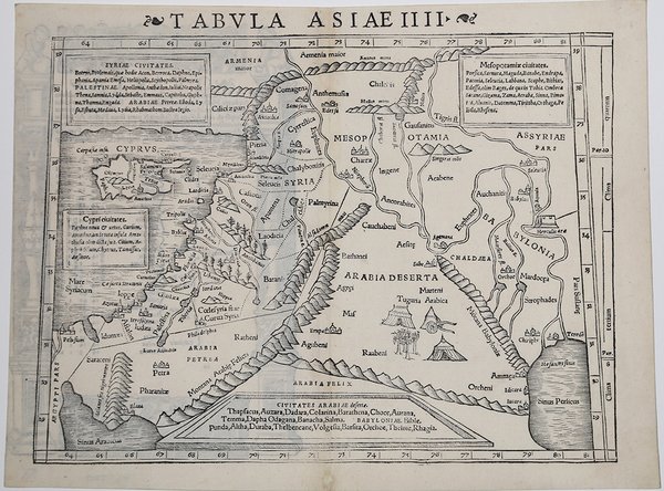
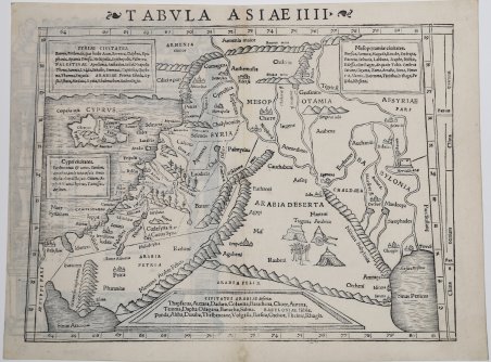
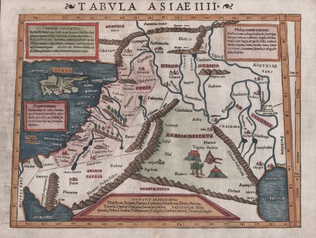
Bell'esemplare della carta di Munster della Terra Santa, Cipro, Siria, ecc., dall'edizione latina del 1542 della Geographia di Munster. ' L'isola di Cipro, raffigurata in basso a sinistra nella mappa, è straordinariamente ben formata, con i nomi dei luoghi iscritti in tutta l'isola che forniscono una coinvolgente istantanea storica. Allo stesso modo, la rappresentazione della Terra Santa è ricca di dati storici e geografici dell'antichità, offrendo una guida dettagliata della regione come conosciuta da Tolomeo. Anche la Siria, la Mesopotamia e l'Arabia trovano il loro posto su questa mappa, con le città segnalate in riquadri di testo distinti. ' Particolarmente degna di nota è la descrizione del deserto arabo fatta da Munster. Immagini accuratamente rese di tende beduine, un carro e un'oasi vicino alle località di Raabeni e Tugaria conferiscono un'aria di autenticità vissuta al terreno desertico in gran parte disadorno. ' Carta tratta dalla ' Geographia universalis, vetus et nova, complectens. Claudii Ptolemaei Alexandrini Ennarationis libros VIII, pubblicata per la prima volta nel 1540 a Basilea da Heinrich Petri, figliastro di Münster e suo fidatissimo stampatore. Il volume è illustrato da 27 carte costruite seguendo le indicazioni di Tolomeo, a cui si affiancano 21 carte “moderne”, delineate in base alle recenti scoperte geografiche. La Geographia di Münster ebbe un notevole successo, e Petri la ristampò l'anno seguente (1541) e quello successivo ancora. Aumentate di sei le carte moderne, tra le quali la Carta Marina di Olao Magnus descrittiva della Scandinavia, l'editore la ristampò ancora nel 1545, nel 1551 e infine nel 1552, sempre con 54 carte geografiche, ma con la sostituzione della Pomerania al posto del Lago di Costanza. Alla scomparsa di Münster l’opera non venne più ristampata; alcune delle carte furono invece utilizzate da Heinrich Petri per le edizioni postume della Cosmographiae Universalis. Le matrici lignee, debitamente emendate, furono poi utilizzate per il Rerum Geographicarum dello Strabo, edizione stampata a Basileae: Ex Officina Henricpetriana, 1571 Mense Augusto. Silografia, finemente colorata a mano, in ottimo stato di conservazione. Nice example of Munster's map of the Holy Land, Cyprus, Syria, etc., from the 1542 Latin edition of Munster's ' Geographia. Sebastian Munster's "Tabulae Asiae IIII" ' offers a rich depiction of geographical knowledge Claudius Ptolemy, through the interpretive eyes of one of the 16th Century's most important geographers, Sebastian Munster. ' ' The ancient island of Cyprus, depicted in the bottom left of the map, is remarkably well-formed, with place-names inscribed across the island providing ' an engaging historical snapshot. Similarly, the representation of the Holy Land is filled with historical and geographical data from ancient times, offering a detailed guide to the region as known to Ptolemy. Syria, Mesopotamia, and Arabia each find their place on this map as well, with key cities noted in distinct text boxes. ' ' Munster's detailing of the Arabian Desert is particularly noteworthy. Carefully rendered images of Bedouin tents, a wagon, and an oasis near the locations Raabeni and Tugaria lend an air of lived authenticity to the largely unadorned desert terrain. These illustrations serve as pictorial narratives, telling tales of nomadic life and survival in the barren landscapes, breaking the monotony of the otherwise sparse desert expanse. Map taken from the ' Geographia universalis, vetus et nova, complectens. Claudii Ptolemaei Alexandrini Ennarationis libros VIII, ' published for the first time in 1540 in Basel by Heinrich Petri, stepson of Münster and his trusted printer. The book is illustrated by 27 maps built following the indications of Ptolemy, which are flanked by 21 "modern" maps, outlined on the basis of recent geographical discoveries. The ' Geographia ' of Münster was a great success, and Petri reprinted it the following year (1541) and then in 1542. Having increased the number of modern maps by six, including the ' Carta Marina ' of Olao Magnus describing Scandinavia, the publisher reprinted it again in 1545, in 1551 and finally in 1552, still with 54 maps, but with the substitution of ' Pomerania ' in place of ' Lake Constance. At the death of Münster the work was not reprinted; some of the maps were instead used by Heinrich Petri for the posthumous editions of the ' Cosmographiae Universalis. The woodblock of the maps, duly amended, were used for the ' Rerum Geographicarum ' of Strabo, edition printed in ' Basileae: Ex Officina Henricpetriana, 1571 Mense Augusto. Woodcut, fine later hand colour, in excellent condition. Cfr.

 Scopri come utilizzare
 Scopri come utilizzare