Dettagli
Anno di pubblicazione
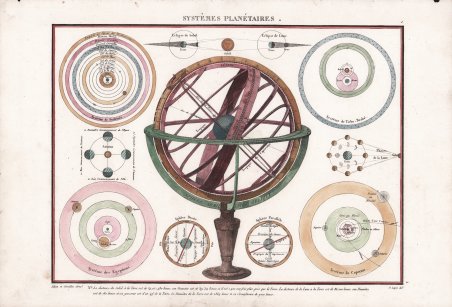
1816
Incisori
LAPIE Pierre Marie
Descrizione
Carta dei sistemi planetari di Pierre M. Lapie del 1816. Questa splendida carta incisa è composta da undici elementi a tema astronomico, tra cui una grande sfera armillare centrale, una mappa dell'universo tolemaico, un'illustrazione delle fasi lunari, un'illustrazione della teoria planetaria di Tycho-Brahe, una carta delle eclissi, un'illustrazione dell'universo copernicano e un'illustrazione dell'attuale sistema solare. Tratta da Atlas classique et universel de géographie ancienne et modern dressé pour linstruction de la jeunesse, et notamment pour les collèges royaux, et les écoles militaires, stampato a Parigi nel 1816. Pierre M. Lapie (nato nel 1779 e morto nel 1850) e suo figlio Alexandre Emile Lapie (nato nel 1809 e morto nel 1850) furono cartografi e incisori francesi attivi nella prima parte del XIX secolo. I Lapie erano ufficiali dell'esercito francese, rispettivamente colonnello e capitano. Alexander si fregiava del titolo di “Primo Geografo del Re”, titolo che compare su molti dei suoi atlanti. Sia il padre che il figlio erano incisori eccezionali e cartografi esigenti. Lavorando separatamente e congiuntamente, pubblicarono quattro importanti atlanti: l'Atlante dell'Impero francese del 1811 (Alexander), l'Atlas Classique et Universel del 1812 (Pierre), l'Atlas Universel de Geographie Ancienne et Modern (edizione congiunta) e l'Atlas Militaire del 1848 (Alexander). Acquaforte, finemente colorata a mano, in ottimo stato di conservazione. Lapie's 1816 chart of the planetary systems. This beautifully engraved chart consists of eleven astronomically themed elements including a large central armillary sphere, a map of the Ptolemaic Universe, an illustration of lunar phases, a illustrations of Tycho-Brahe's planetary theory, an illustration of the Copernican Universe, and an illustration of the actual solar system, among others. From Atlas classique et universel de géographie ancienne et modern dressé pour linstruction de la jeunesse, et notamment pour les collèges royaux, et les écoles militaires, printed in Paris 1816. Pierre M. Lapie (fl. 1779 - 1850) and his son Alexandre Emile Lapie (fl. 1809 - 1850) were French cartographers and engravers active in the early part of the 19th century. The Lapies were commissioned officers in the French army holding the ranks of Colonel and Capitan, respectively. Alexander enjoyed the title of "First Geographer to the King", and this title appears on several of his atlases. Both father and son were exceptional engravers and fastidious cartographers. Working separately and jointly they published four important atlases, an 1811 Atlas of the French Empire (Alexander), the 1812 ' Atlas Classique et Universel ' (Pierre), the ' Atlas Universel de Geographie Ancienne et Modern ' (joint issue), and the 1848 ' Atlas Militaire ' (Alexander). They also issued many smaller maps and independent issues. Etching with fine later hand colour, good condition. Cfr.

 Scopri come utilizzare
 Scopri come utilizzare