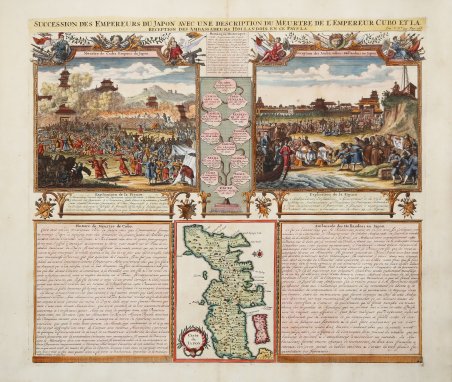
Interessante incisione raffigurante la morte dell'imperatore Cubo, l'arrivo di una delle prime ambasciate olandesi in Giappone (a Mia nel 1644) e una piccola mappa dell'isola principale di Honsh?. Foglio inserito nell'Atlas Historique, pubblicato ad Amsterdam tra il 1705 e il 1720. L'atlante, in 7 volumi, è innovativo per la sua epoca perché combina le mappe geografiche con incisioni e informazioni di carattere storico, etnografico ed araldico. Henri Abraham Chatelain (1684 - 1743) era un pastore ugonotto di origini parigine. È meglio conosciuto come cartografo olandese e più specificamente per il suo contributo cartografico nell’Atlas Historique in sette volumi, pubblicato ad Amsterdam tra il 1705 e il 1720. Innovativo per il suo tempo, l'Atlas Historique combinava incisioni e opere d'arte con studi di geografia, storia, etnologia, araldica e cosmografia. Alcuni studiosi suggeriscono che l'Atlas Historique non fu compilato esclusivamente da Henri Chatelain, come si crede comunemente, ma piuttosto fu un'impresa familiare che coinvolse Henri, suo padre Zacharie e suo fratello, sempre Zacharie. “For the second map of Japan in the Atlas Historique, Châtelain has inserted a more traditional representation, probably borrowed from Pieter van der Aa who, in turn, drew on Sanson's model of 1652. The miniature map is sandwiched at bottom centre of the sheet between two blocks of text, one dealing with the death of the emperor of Japan and the other with the Dutch 'Embassy' of 1644." (Hubbard "Japoniae Insulae – The Mapping of Japan", p. 295). Acquaforte, finemente colorata a mano, in ottimo stato di conservazione. ' Bibliografia: Hubbard "Japoniae Insulae – The Mapping of Japan", pp. 295-296, n. 74; Walter "Japan a cartographic vision", p. 219, n. 72. A fine folio sheet of engravings depicting the death of the Emperor Cubo and the arrival of one of the early Dutch embassies to Japan (at Mia in 1644) and a small map of the main island Honshu. Taken from ' Atlas Historique, published in Amsterdam between 1705 and 1720. Henri Abraham Chatelain (1684 - 1743) was a Huguenot pastor of Parisian origins. He is best known as a Dutch cartographer and more specifically for his cartographic contribution in the seminal seven volume ' Atlas Historique, published in Amsterdam between 1705 and 1720. Innovative for its time, the ' Atlas Historique ' combined fine engraving and artwork with scholarly studies of geography, history, ethnology, heraldry, and cosmography. Some scholarship suggests that the ' Atlas Historique ' was not exclusively compiled by Henri Chatelain, as is commonly believed, but rather was a family enterprise involving Henri, his father Zacharie and his brother, also Zacharie. “For the second map of Japan in the Atlas Historique, Châtelain has inserted a more traditional representation, probably borrowed from Pieter van der Aa who, in turn, drew on Sanson's model of 1652. The miniature map is sandwiched at bottom centre of the sheet between two blocks of text, one dealing with the death of the emperor of Japan and the other with the Dutch 'Embassy' of 1644." (Hubbard "Japoniae Insulae – The Mapping of Japan", p. 295). Copper engraving with fine later hand colour, in excellent condition. ' Bibliografia: Hubbard "Japoniae Insulae – The Mapping of Japan", pp. 295-296, n. 74; Walter "Japan a cartographic vision", p. 219, n. 72. Cfr.

 Scopri come utilizzare
 Scopri come utilizzare