Sicilia Antiqua quae et Sicania et Trinacria dicta
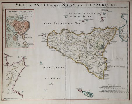
Sicilia Antiqua quae et Sicania et Trinacria dicta
Metodi di Pagamento
- PayPal
- Carta di Credito
- Bonifico Bancario
- Pubblica amministrazione
- Carta del Docente
Dettagli
- Anno di pubblicazione
- 1754
- Luogo di stampa
- Londra
- Formato
- 570 X 430
- Incisori
- BLAIR John
Descrizione
Splendida carta geografica di grande formato incentrata sull'isola di Sicilia, con un grande inserto con la pianta dell'antica Siracusa. Include numerose isole, tra cui Malta, Ustica e Stromboli. Rappresentazione altamente dettagliata della Sicilia, compreso il Monte Aetna in piena eruzione vulcanica. Mostra città, montagne, fiumi, strade, laghi, isole, porti, ecc. Mappa tratta dalla Chronology and History of the World di John Blair, pubblicata per la prima volta nel 1754. Acquaforte, colorata a mano, in buono stato di conservazione. Bibliografia V. Valerio, Sicilia 1477-1861, p. 380, n. 184 (non descritta né illustrata, ma censita sotto la carta di De L’Isle). This is a handsome and detailed map of ancient Sicily, extending to include numerous surrounding islands and the tip of Italy and Tunisia. The map depicts towns, roads, rivers, mountains, and a huge, flaming Mt. Etna. At top left is a large inset with a bird's-eye plan of Syracuse. Gorgeous large format map centered on the island of Sicily, with a large inset town plan of Ancient Syracuse. Includes a number of Islands, including Malta, Ustica and Stromboli. Highly detailed depiction of Sicily, including Mount Aetna in full volcanic eruption. Shows towns, mountains, rivers, roads, lakes, islands, harbors, etc. The inset plan of Syracuse is one of the few large format maps of Syracuse to appear during the period. From John Blair's Chronology and History of the World, first published in 1754. Etching with late hand colour, good condition. Bibliografia V. Valerio, Sicilia 1477-1861, p. 380, n. 184. ' Cfr.