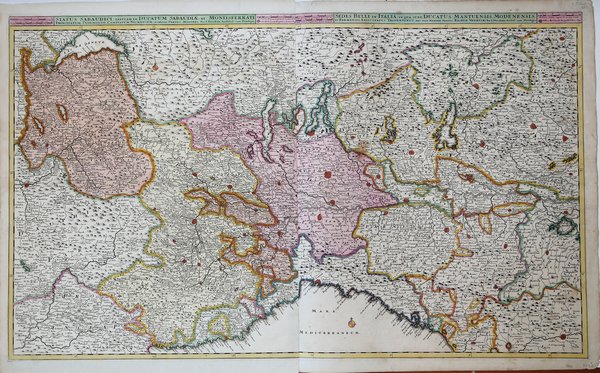
Carta geografica dell'Italia settentrionale. La firma dell'editore Justus Dankerts, defunto nel 1701, dovrebbe collocare l'esecuzione di questa carta entra tale anno, che rappresenta anche l'anno di inizio della guerra di Successione spagnola a cui fa riferimento il titolo. I Danckerts erano una famiglia di incisori e geografi olandesi che producevano materiale geografico, tra cui una serie di atlanti originali. Inizialmente, Justus I Danckerts (1635-1701) era un editore di libri e stampe con sede ad Amsterdam. Il suo prozio, Cornelis Danckerts de Rij (1561-1634), era un topografo che produsse un Kaert-boeck con varie vedute di Amsterdam. Suo fratello, Dancker Danckerts (1634-1666), fu un abile incisore che produsse diverse mappe. Molto probabilmente Justus I fu influenzato dal lavoro di entrambi quando seguì il padre, Cornelis I Danckerts (1603-1656), nell'attività editoriale. All'inizio degli anni '80 del XVI secolo, Justus decise di intraprendere un nuovo progetto, un atlante con tutte le mappe realizzate in casa. Questo progetto era realizzabile perché due dei suoi figli con la moglie, Elisabeth Vorsterman, Teodoro I (1663 ca. - 1720 ca.) e Cornelis II (1664-1717), erano da poco diventati maggiorenni e avevano una formazione in incisione e acquaforte. La decisione di Justus fu probabilmente influenzata dall'ambiente circostante; Amsterdam era il centro dell'editoria cartografica del XVII secolo e negli anni '80 del XVI secolo diversi editori locali cercarono di entrare nel mercato degli atlanti, allora dominato dagli atlanti Blaeu e Hondius-Janssonius. Insieme, i fratelli crearono le loro prime mappe a metà degli anni '80 del XVI secolo. Nel 1684, la famiglia ottenne un privilegio di 15 anni per la protezione delle proprie mappe e pubblicò sia mappe in formato in-folio, la base di un atlante, sia mappe murali per la vendita. I loro primi atlanti contenevano circa 20 mappe originali e 4-5 mappe di altri cartografi come Visscher e De Wit. Il primo atlante di cui si abbia notizia che contenga solo mappe di Danckerts è un volume di 26 fogli pubblicato nel 1690. Come esempio, i Danckerts si rivolsero ad atlanti simili di De Wit, ma nel 1690 avevano chiaramente la conoscenza e la capacità di produrre un proprio lavoro originale. Sebbene non sia stata così longeva come altre imprese familiari, per i decenni a cavallo del Seicento la famiglia Danckerts produsse mappe murali e atlanti molto apprezzati e ampiamente distribuiti. L'ingresso nel commercio degli atlanti avvenne in un momento di crescente popolarità e l'espansione del numero di fogli inclusi nei loro atlanti indica sia la loro popolarità sia l'abilità dei fratelli incisori. Incisione in rame, due fogli uniti, magnifica coloritura coeva con ritocchi, in perfette condizioni. Bibliografia: Terre di Langobardia p. 88, 35. Old coloured, detailed, copper engraving of north Italy. The Danckerts were a family of Dutch engravers and geographers who produced geographic materials, including a series of original atlases. Initially, Justus I Danckerts (1635-1701) was a book and print publisher based in Amsterdam. His great-uncle, Cornelis Danckerts de Rij, (1561-1634) was a surveyor who produced a Kaert-boeck showing various views of Amsterdam. His brother, Dancker Danckerts (1634-1666), was a skilled engraver who produced several maps. Justus I was most likely influenced by both their work when he followed his father, Cornelis I Danckerts (1603-1656), into the publishing business. ' In the early 1680s, Justus decided to embark upon a new project, an atlas with all the maps made in house. Such a project was feasible because two of his sons with his wife, Elisabeth Vorsterman, Theodorus I (ca. 1663-ca. 1720) and Cornelis II (1664-1717) had recently come of age and were trained in engraving and etching. Justus’ decision was most likely influenced by his surroundings; Amsterdam was the center of map publishing in the seventeenth century and in the 1680s several local publishers sought to join the atlas market then dominated by the Blaeu and the Hondius-Janssonius atlases. ' Together, the brothers created their first maps in the mid-1680s. In 1684, the family received a 15-year privilege to protect their maps and they were then publishing both folios sized maps, the basis of an atlas, and wall maps for sale. Although not as long-lived as some of the other family firms, for the decades surrounding the turn of the seventeenth-century the Danckert family produced well-respected and widely distributed wall maps and atlases. They joined the atlas trade at a time when atlases were increasing in popularity and the expansion in the number of sheets included in their atlases indicate both their popularity and the skill of the engraving brothers. ' Cfr.


 Scopri come utilizzare
 Scopri come utilizzare