Royaume de Maroc divise en sept Provinces & e.
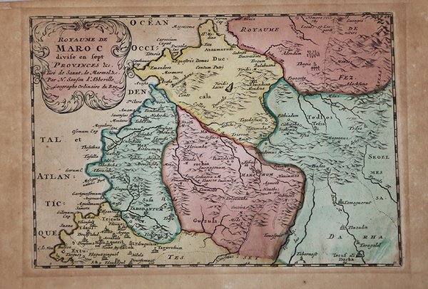

Royaume de Maroc divise en sept Provinces & e.
Metodi di Pagamento
- PayPal
- Carta di Credito
- Bonifico Bancario
- Pubblica amministrazione
- Carta del Docente
Dettagli
- Anno di pubblicazione
- 1656
- Luogo di stampa
- Parigi
- Formato
- 240 X 170
- Incisori
- SANSON Nicolas
Descrizione
Carta geografica tratta da "L'Europe. Dediée a Monseigneur/ Monseigneur le Tellier Secret. d' Estat/ par N. Sanson le fils Geograph du Roy" stampatao a Parigi nel 1656.Sanson era il più famoso cartografo francese della storia moderna, cosmografo al servizio di Luigi XIV, re di Francia; dotò le sue mappe delle più recenti informazioni geografiche e delle incisioni più belle e acute del periodo. Il "Cartes Generales de Toutes les Parties du Monde" rappresenta il più importante prodotto della cartografia commerciale francese del diciassettesimo secolo.Le mappe furono compilate a partire dal 1630 e l'atlante edito per la prima volta nel 1654, stampato da Pierre Mariette. Published in an early edition of the small Sanson atlas L'Europe Dediée a Monseigneur . . . Le Tellier Secret. D'Estat &c."The atlas proved popular and the maps were imitated by Johann Zunners in Frankfurt (1679) and by Joannes Ribbius and François Halma (1682-1730s). The maps were compiled by Nicolas Sanson who published his atlas in 1654, with 100 maps, and printed by Pierre Mariette; they were issued progressively from 1630. Sanson was the most noted French cartographer in modern history. Mapmaker to Louis XIV, King of France, Sanson endowed his maps with the most recent geographical information as well as the finest and sharpest engraving of the period. His "Cartes Generales de Toutes les Parties du Monde" was the most important single product of French commercial cartography of the seventeenth century.Copperplate, good condition. Cfr.