Dettagli
Anno di pubblicazione
1872
Descrizione
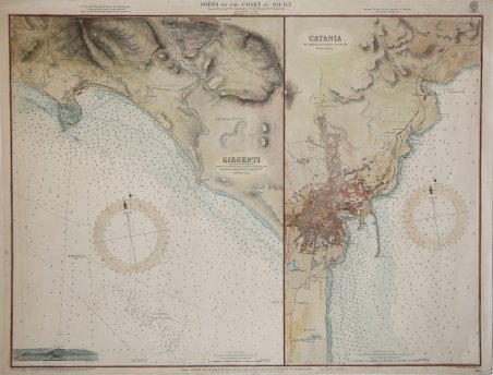
Coppia di carte nautiche in un foglio: a sinistra si trova la carta incentrata sulla zona di Agrigento, con il vicino Porto Empedocle, per il quale viene fornito il piano nautico con il pescaggio delle banchine. A destra sono raffigurati i dintorni di Catania, con un’accurata descrizione della pianta della città e del suo porto, del quale vengono descritte banchine e profondità. Nel mare linee batimetriche e una rosa dei venti. Le "Admiralty Chart" sono carte nautiche prodotte dallo United Kingdom Hydrographic Office, per soddisfare le necessità della navigazione sia commerciale che da diporto. Le carte Admiralty forniscono una copertura globale in tre varietà di scale a seconda delle richieste: grande scala per porti ed ancoraggi o per passaggi in prossimità di aree pericolose per la navigazione, media scala per la navigazione costiera, piccola scala per la navigazione d'altura e per i piani di navigazione. Lo United Kingdom Hydrographic Office fu fondato nel 1795. Il primo Idrografo dell'Admiralty fu Alexander Dalrymple, nominato dal re Giorgio III, mentre la prima carta - di Baia Quiberon, in Bretagna - sembra sia stata edita nel 1800. Incisione in rame, finemente colorata a mano, in buono stato di conservazione. Pair of nautical charts on one sheet: on the left is a chart focusing on the area of Agrigento, with the nearby Port Empedocle, for which a nautical plan is provided with the draft of the docks. On the right are depicted the surroundings of Catania, with an accurate description of the plan of the city and its port, of which docks and depths are described. In the sea bathymetric lines and a wind rose. Printed in 1872, this map is the 1884 update. Admiralty charts are nautical charts issued by the United Kingdom Hydrographic Office and subject to Crown Copyright. Over 3,000 charts are available and cover virtually the entire world in various levels of detail depending on the density of traffic and hazards. Large-scale charts often cover approaches and entrances to harbours, medium-scale charts cover heavily used coastal areas, and small-scale charts are for navigation in more open areas. There is also a Small Crafts Series available at even smaller scales. The United Kingdom Hydrographic Office (or UKHO) is an organisation within the UK government responsible for providing navigational and other hydrographic information for national, civil and defence requirements. The Admiralty's first Hydrographer was Alexander Dalrymple, appointed in 1795 on the order of King George III and in the next year the existing charts were brought together and catalogued. The first chart the Admiralty produced (of Quiberon Bay in Brittany) did not appear until 1800. Cfr.

Scopri come utilizzare
Scopri come utilizzare

