Dettagli
Anno di pubblicazione
1603
Incisori
ORTELIUS Abraham
Soggetto
Frontespizi e Allegorie
Descrizione
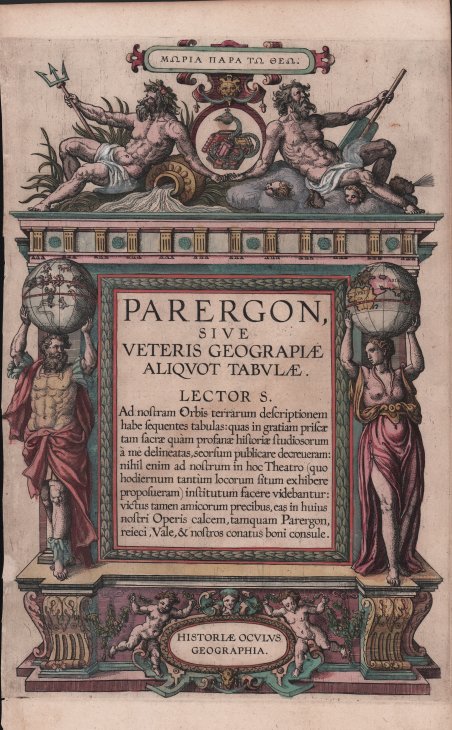
Meraviglioso esemplare del frontespizio del Parergon di Abraham Ortelius, stampato per l’edizione latina del 1603 curata da Johannes Baptiste Vrients. Esemplare nel primo stato di quattro. Titolo in alto in greco Mooria para too Theoo. Al centro: PARERGON, | SIVE | VETERIS GEOGRAPIÆ | ALIQVOT TABVLÆ. |Ad nostram Orbis Terrarum descriptionem | habe sequentes tabulas: quas in gratiam priscæ | tam sacræ quam profanæ historiæ studiosorum | a me delineatas,seorsum publicare decreueram: | nihil enim ad nostrum in hoc Theatro (quo | hodiernum tantum locorum situm exhibere | proposueram) institutum facere videbantur: | victus tamen amicorum precibus, eas in huius | nostri Operis calcem,tamquam Parergon, | reieci. Vale,& nostros conatus boni consule. HISTORIÆ OCVLVS | GEOGRAPHIA. Circa una decade dopo la pubblicazione del “moderno” ' Theatrum Orbis Terrarum, Ortelius rispose alle “preghiere di amici e studiosi di storia antica, sacra e profana” e compilò una serie di mappe di soggetto biblico e classico, quasi tutte disegnate da lui. Intitolò l’opera “Parergon theatri”, ovvero “aggiunta, appendice, del ' Theatrum”, ma al tempo stesso anche complementare al ' Theatrum: ' il ' Paregon theatri ' forniva per il mondo antico lo stesso materiale che Ortelius aveva fornito per il mondo moderno con il ' Theatrum: carte geografiche. Lo spirito del Parergon è tutto riassunto nel motto ' historiae oculus geographia ' riportato sul frontespizio: la geografia è l’occhio della storia. Le mappe del mondo antico avevano lo scopo di “rendere più chiari gli storici antichi e i poeti”. Le mappe del ' Paregon ' sono di tre tipologie: antiche regioni; carte letterarie e carte bibliche. Come sottolinea Koeman “il ' Parergon ' deve essere considerato come lavoro personale di Ortelius. Per quest'opera, infatti, diversamente dal ' Theatrum, non copiò le mappe di altri cartografi, ma ne disegnò lui stesso di nuove ed originali. Riprese luoghi, regioni e territori delle civiltà classiche illustrandone e spiegandone la storia, una materia molto vicina al suo cuore. Le mappe e le lastre del ' Parergon ' devono essere valutate come le più importanti incisioni che rappresentano il diffuso interesse per la geografia classica nel XVI secolo”. Acquaforte, bellissima coloritura d’epoca, in ottimo stato di conservazione. A striking example of the title page of Ortelius's ' Parergon. Printed for the 1603 Latin edition edited by Johannes Baptiste Vrients. Example in the first state of four. Title in Greek lettering: Mooria para too Theoo. At the center: PARERGON, | SIVE | VETERIS GEOGRAPIÆ | ALIQVOT TABVLÆ. |Ad nostram Orbis Terrarum descriptionem | habe sequentes tabulas: quas in gratiam priscæ | tam sacræ quam profanæ historiæ studiosorum | a me delineatas,seorsum publicare decreueram: | nihil enim ad nostrum in hoc Theatro (quo | hodiernum tantum locorum situm exhibere | proposueram) institutum facere videbantur: | victus tamen amicorum precibus, eas in huius | nostri Operis calcem,tamquam Parergon, | reieci. Vale,& nostros conatus boni consule. HISTORIÆ OCVLVS | GEOGRAPHIA. [Foolishness in the eyes of God. PARERGON or some maps with ancient geography. Dear reader, after our representation of the world, you have here the maps that now follow, which I have designed for the benefit of those interested in old history, both sacred and profane. I had decided to publish these in a separate book, because they did not seem relevant to this Theatre where I only show present day locations. But convinced by the request of my friends, and referring to them, I have now in this work of ours added them at the end as an accessory work. Be well and use our efforts. Geography is the eye of History]. The ' Parergon ' is the first historical atlas ever published. It was initially conceived by Ortelius as an appendix to his ' Theatrum Orbis Terrarum ' but given the considerable success of these historical maps it later became an independent work and remained the main source of all similar works throughout the seventeenth century. Koeman wrote: “This atlas of ancient geography must be regarded as a personal work of Ortelius. For this work he did not, as in the ' Theatrum, ' copy other people's maps but drew the originals himself. He took many places and regions from the lands of classical civilization to illustrate and clarify their history, a subject very close to his heart. The maps and plates of the ' Parergon ' have to be evaluated as the most outstanding engravings depicting the wide-spread interest in classical geography in the 16th century." Copperplate with fine original colouring, in good condition. Cfr.

 Scopri come utilizzare
 Scopri come utilizzare