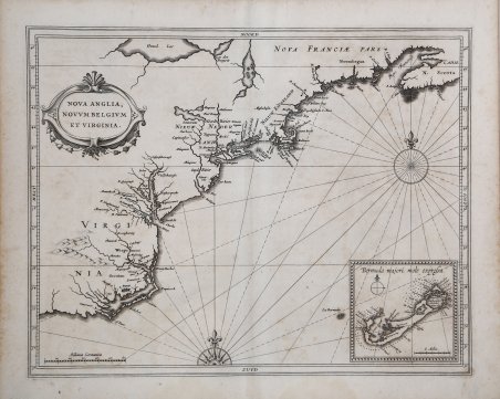
Bellissimo esemplare di questa “Map of Extreme Importance” (Burden), probabilmente la più importante carta del Nord-Est e del Medio Atlantico pubblicata nella prima metà del XVII secolo. La “First printed map of New Netherlands as well as the first printed map that names New Amsterdam and Manhattan . . .” ' (Schwartz), che mostra correttamente Manhattan come un'isola. Quest'opera fondamentale colloca gli insediamenti olandesi del Nord America nel loro contesto geografico solo cinque anni dopo la fondazione di Nuova Amsterdam (New York). Sebbene sia di per sé una carta piuttosto rara, la mappa di De Laet ebbe una lunga vita editoriale grazie alle numerose edizioni di Janssonius, che ne pubblicò una copia, ingrandita, nel 1636 e aggiornandola, nel 1647. Secondo McCorkle, questa è anche la prima mappa con il nome del Massachusetts. È anche una delle prime mappe acquisibili a rappresentare i Grandi Laghi. In genere si ritiene che il "Grand Lac" sulla mappa corrisponda al Lago Superiore e il "Lac de Yroquois" al Lago Huron. Tuttavia, stante la datazione precoce della carta, sembra più probabile, anche se la forma e l'allineamento sono poco somiglianti, che rappresentino i laghi Erie e Ontario. La carta comprende anche un inserto ben dettagliato delle Bermuda, una delle prime mappe separate dell'isola. Johannes De Laet fu uno dei principali protagonisti della fondazione dei “Nuovi Paesi Bassi”: fu direttore della Compagnia olandese delle Indie occidentali, che ne sponsorizzò l'insediamento, e possedeva anche un'ampia proprietà terriera nella zona di Albany. Avrebbe quindi avuto accesso ai rilievi e alle informazioni dei coloni olandesi, il che spiega come abbia prodotto questa bella mappa in una data così precoce. “A map of extreme importance. . . Hessel Gerritsz, the author and probable engraver of the map, had been the official cartographer to the Dutch East India Company since 1617. He would have seen all the documentation and charts from the Dutch voyages into the area of the Hudson River. His depiction of the coastal area between Chesapeake Bay and Cape Cod is by far the finest yet seen. This despite the fact that he still shows the Delaware River flowing from a lake. This is descended from the so-called figurative map of Cornelis Hendrick, 1616. The map . . . exhibits signs of being familiar with the other important derivative map of the period, that of Adrian Block, 1614. This is the first occurrence of NOVVUM BELIGVM, or New Netherlands, in the title. The reason for it being referred to here as Belgium is that the majority of the backing of the Dutch West India Company was by Walloon Protestants of that region” (cf. P. Burden, Mapping of North America: A List of Printed Maps 1511-1670, n. 231). Quella di De Laet fu la prima mappa a nominare in qualsiasi forma Manhattan, Nuova Amsterdam, il fiume Nord (Hudson) e il fiume Sud (Delaware), oltre alla prima apparizione del Massachusetts (e della colonia inglese appena fondata). La mappa di De Laet apparve nella sua opera fondamentale sull'America, che è ampiamente considerata come il più importante e influente trattato sull'argomento pubblicato nel XVII secolo, il celebre ' Novus Orbis seu descriptionis Indiae occidentalis Libri XVIII ' stampato a ' Lugduni Batavorum: Elzevir, 1633. ' Terza edizione di una delle più importanti collezioni di viaggi nel Nuovo Mondo del diciassettesimo secolo, compilata dal direttore della neonata Compagnia Olandese delle Indie Occidentali, Johannes de Laet (1581-1649). Le edizioni precedenti furono pubblicate: la prima ad Anversa in olandese (1625), la seconda edizione – la prima in latino - a Leida, nel 1630, sempre dall’editore Elzevir. L’edizione del 1633 include per la prima volta quattro mappe regionali americane: "Americae sive Indiae Occidentalis", la migliore delineazione della costa occidentale che raffigura la California come una penisola e non un'isola, e fermandosi alla controversa regione del Passagg. Attractive example of a “Map of Extreme Importance” (Burden); quite possibly the most important ' map of the Northeast & Mid-Atlantic published in the first half of the 17th Century. “First printed map of New Netherlands as well as the first printed map that names New Amsterdam and Manhattan . . .” ' (Schwartz). It is also the first collectible map to correctly show Manhattan as an island. This landmark work places the Dutch North American settlements in their geographic context just five years after the founding of New Amsterdam. Though itself a scarce map, De Laet’s map had a long publishing life through the many issues of Jansson’s close re-engravings of it of 1636 and 1647. According the McCorkle, this is also the first map with the place name Massachusetts. It is also among earliest acquirable maps to represent any of the Great Lakes. ‘Grand Lac’ on the map has generally been thought to be Lake Superior, which would make ‘Lac de Yroquois’ Lake Huron. However, given the early date of the map, it seems more likely that it is Lakes Erie and Ontario represented on the map, though there is little resemblance in shape and alignment. The map also includes a well-detailed inset of Bermuda, which is one of the earliest separate maps of the island. Johannes De Laet was a principal player in the founding of New Netherlands; he was a Director of the Dutch West India Company, which sponsored its settlement, and he also owned a large tract of land in the area of Albany. He therefore would have had access to surveys and information from Dutch colonists, which explains how he produced this fine map at such an early date. Johannes De Laet's highly influential map of the East Coast of North America is a cartographic landmark, depicting the region at a time when Dutch and English regional settlements were beginning to accelerate. “A map of extreme importance. . . Hessel Gerritsz, the author and probable engraver of the map, had been the official cartographer to the Dutch East India Company since 1617. He would have seen all the documentation and charts from the Dutch voyages into the area of the Hudson River. His depiction of the coastal area between Chesapeake Bay and Cape Cod is by far the finest yet seen. This despite the fact that he still shows the Delaware River flowing from a lake. This is descended from the so-called figurative map of Cornelis Hendrick, 1616. The map . . . exhibits signs of being familiar with the other important derivative map of the period, that of Adrian Block, 1614. This is the first occurrence of NOVVUM BELIGVM, or New Netherlands, in the title. The reason for it being referred to here as Belgium is that the majority of the backing of the Dutch West India Company was by Walloon Protestants of that region” (cf. P. Burden, Mapping of North America: A List of Printed Maps 1511-1670, n. 231). De Laet's map was the first map to name in any form Manhattan, New Amsterdam, the North River (Hudson) and South River (Delaware), along with the first appearance of Massachusetts (and the recently established English Colony therein). De Laet's map appeared in his seminal work on America, which is widely regarded as the most important and influential treatise on the subject published in the 17th Century, the ' Novus Orbis seu descriptionis Indiae occidentalis Libri XVIII ' printed in ' Lugduni Batavorum: Elzevir, 1633. Third edition of one of the most important of seventeenth-century New World voyages collections, compiled by a director of the recently formed Dutch West India Company, Johannes de Laet (1581-1649). Previous editions were published: the first in Antwerp in Dutch (1625), the second edition-the first in Latin-in Leiden, in 1630, also by the publisher Elzevir. This issue include for the first time four American regional maps: "Americae sive Indiae Occidentalis", the best West Coast delineation to date, and interestingly depicting California as a peninsula not an island, and stopping sho. Cfr.

 Scopri come utilizzare
 Scopri come utilizzare