Dettagli
Anno di pubblicazione
1813
Descrizione
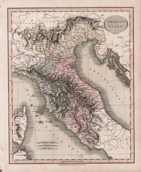
Bella mappa dell’Italia centro-settentrionale, tratta dal New Universal Atlas di John Cary. Si tratta di una versione compatta del suo General Atlas e mostra l'elevato standard di progettazione, stampa e accuratezza geografica che ha portato molti a considerare Cary come il migliore dei cartografi inglesi. John Cary (1755-1835) è stato un cartografo e editore britannico noto soprattutto per le sue incisioni pulite e per il suo stile distinto che ha influenzato l'intero settore cartografico. Nato nel Wiltshire, John fu apprendista incisore a Londra. Nel 1782 avviò la propria attività e si trasferì in diversi locali prima di stabilirsi all'86 di St James's Street nel 1820. Nel corso della sua carriera, Cary ebbe diverse collaborazioni significative. John Wallis e Cary diversificarono l'attività di Cary per includere progetti editoriali più ampi. I fratelli William e John realizzarono insieme dei globi, mentre il fratello Francis partecipò al lavoro di incisione dell'azienda. Infine, il geologo William Smith e Cary svilupparono e vendettero mappe geologiche, alcune delle prime del loro genere. La coppia produsse anche una notevole serie di mappe di contea a partire dal 1819. Gli atlanti di Cary, delle contee inglesi e del mondo, erano i testi standard dell'inizio del XIX secolo. Nel 1794 fu nominato ispettore delle strade per il General Post Office, il che portò al New Itinerary, pubblicato per la prima volta nel 1798. ' John istruì il figlio George nell'incisione e George e l'altro figlio, John Jr, rilevarono l'attività nel 1821. L'azienda era allora conosciuta come G. e J. Cary e continuò a operare fino al 1850. I materiali dell'azienda furono poi acquisiti da George Frederick Cruchley e quindi da Gall e Inglis. Alla morte di John, nel 1835, Cary era il nome più autorevole nell'editoria cartografica privata e la sua azienda fu leader nel settore per tutta la prima metà del XIX secolo. This beautiful map, accurate and concise, is from John Cary's New Universal Atlas. This was a compact version of his General Atlas, and shows the high standard of design, printing, and geographical accuracy that has led many to consider Cary as the finest of English map-makers. John Cary (1755-1835) was a British cartographer and publisher best known for his clean engraving and distinct style which influenced the entire map industry. Born in Wiltshire, John was apprenticed to an engraver in London. He started his own business by 1782 and moved to several premises before settling at 86 St James’s Street in 1820. Cary had several significant collaborations during his career. John Wallis and Cary diversified Cary’s business to include broader publishing projects. Brother William and John made globes together, while brother Francis participated in the company’s engraving work. Finally, geologist William Smith and Cary developed and sold geological maps, some of the first of their kind. The pair also produced a notable series of county maps starting in 1819. Cary’s atlases, of English counties and the world, were the standard texts of the early nineteenth century. He was appointed surveyor of roads to the General Post Office in 1794, which led to the New Itinerary, first published in 1798. ' John trained his son, George, in engraving and George and his other son, John Jr., took over the business in 1821. It was then known as G. and J. Cary and continued in trade until 1850. The firm’s materials were then acquired by George Frederick Cruchley and then Gall and Inglis. By the time John died in 1835, Cary was the authoritative name in private map publishing and his business was a leader in the field throughout the first half of the nineteenth century. Cfr.

 Scopri come utilizzare
 Scopri come utilizzare