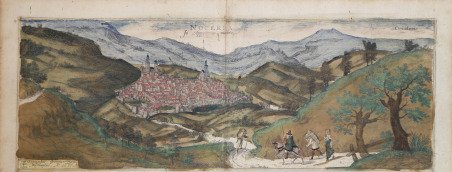
Veduta di Nocera Umbra secondo un dipinto di G. Hoefnagel, 1577. L'opera è inclusa nel Civitates Orbis Terrarum, il primo atlante dedicato esclusivamente alle piante e alle vedute delle principali città del mondo. ' La veduta mostra Nocera Umbra situata su un crinale in un paesaggio montuoso a nord di Foligno. Nel punto più alto della città, ben fortificata, si ergono la cattedrale e la trecentesca torre del Campanaccio, già parte della fortezza dei Trinci. Sulla destra spicca la chiesa di San Francesco, oggi sede del museo d'arte di Nocera Umbra. ' Il primo volume delle ' Civitates Orbis Terrarum ' fu pubblicato a Colonia nel 1572. Il sesto e ultimo volume apparve nel 1617. Questo grande atlante di città – cartografia urbana - curato da Georg Braun e inciso in gran parte da Franz Hogenberg, conteneva 546 prospettive, vedute a volo d'uccello e vedute cartografiche di città di tutto il mondo. Franz Hogenberg realizzò le tavole dei primi quattro volumi e Simon van den Neuwel (Novellanus, attivo dal 1580) quelle dei volumi V e VI. Georg Braun (1541-1622), un ecclesiastico di Colonia, fu il principale redattore dell'opera e fu molto aiutato nel suo progetto dalla vicinanza e dal continuo interesse di Abraham Ortelius, il cui ' Theatrum Orbis Terrarum ' del 1570 fu, come raccolta sistematica e completa di mappe di stile uniforme, il primo vero atlante. Le ' Civitates, ' in effetti, erano destinate ad accompagnare il ' Theatrum, ' come indicato dalla somiglianza dei titoli e dai riferimenti contemporanei sulla natura complementare delle due opere. Tuttavia, le ' Civitates ' erano progettate per avere un approccio più popolare, senza dubbio perché la novità di una raccolta di piante e vedute di città rappresentava un'impresa commerciale più rischiosa di un atlante mondiale, per il quale c'erano stati diversi precedenti di successo. Franz Hogenberg (1535-1590) era figlio di un incisore di Monaco che si era stabilito a Malines. Incise la maggior parte delle tavole del ' Theatrum ' di Ortelius e la maggior parte di quelle delle ' Civitates, e potrebbe essere anche indicato come il responsabile dell'origine del progetto. Oltre un centinaio di artisti e cartografi diversi, il più importante dei quali fu l'artista di Anversa Georg Hoefnagel (1542-1600), fornirono i disegni per le tavole delle ' Civitates. Hoefnagel non solo contribuì alla maggior parte del materiale originale per le città spagnole e italiane, ma rielaborò e modificò anche quello di altri collaboratori. Dopo la morte di Hoefnagel, il figlio Jakob continuò il lavoro per le ' Civitates. Gli autori della raccolta si proponevano di raffigurare "non icones et typi urbium", cioè non immagini generiche e tipizzate, "sed urbes ipsae admirabili caelaturae artificio, spectantium oculis subiectae appareant": non intendeva alludere o idealizzare, ma rappresentare fedelmente sulla carta, riprodurre esattamente, e in tempo reale, ciò che l'occhio vede, come annunciato nella prefazione al primo volume delle ' Civitates Orbis Terrarum. Incisione in rame, finemente colorata a mano, in ottimo stato di conservazione. View of Nocera Umbra after a painting by G. Hoefnagel, 1577. The work is included in the ' Civitates Orbis Terrarum, the first atlas devoted exclusively to plans and views of the world's major cities. ' The view shows Nocera Umbra situated on a ridge in a mountainous landscape north of Foligno. Rising at the highest point of the well-fortified town are the cathedral and the 14th-century Campanaccio tower, formely part of the Trinci fortress. Prominent on the right is the church of San Francesco, today home to the Nocera Umbra museum of art. ' The first volume of the ' Civitates Orbis Terrarum ' was published in Cologne in 1572. The sixth and the final volume appeared in 1617. This great city atlas, edited by Georg Braun and largely engraved by Franz Hogenberg, eventually contained 546 prospects, bird-eye views and map views of cities from all over the world. Fransz Hogenberg produced the plates for the first four books, and Simon van den Neuwel (Novellanus, active since 1580) those for volumes V and VI. Georg Braun (1541-1622), a cleric of Cologne, was the principal editor of the work, and was greatly assisted in his project by the close, and continued interest of Abraham Ortelius, whose ' Theatrum Orbis Terrarum ' of 1570 was, as a systematic and comprehensive collection of maps of uniform style, the first true atlas. The ' Civitates, ' indeed, was intended as a companion for the ' Theatrum, ' as indicated by the similarity in the titles and by contemporary references regarding the complementary nature of two works. Nevertheless, the ' Civitates ' was designs to be more popular in approach, no doubt because the novelty of a collection of city plans and views represented a more hazardous commercial undertaking than a world atlas, for which there had been a number of successful precedents. Franz Hogenberg (1535-1590) was the son of a Munich engraves who settled in Malines. He engraved most of the plates for Ortelius's ' Theatrum ' and the majority of those in the ' Civitates, and may have been responsible for originating the project. Over a hundred of different artists and cartographers, the most significant of whom was Antwerp artist Georg Hoefnagel (1542-1600), engraved the cooper-plates of the ' Civitates ' from drawings. He not only contributed most of the original material for the Spanish and Italian towns but also reworked and modified those of other contributors. After Hoefnagel's death his son Jakob continued the work for the Civitates. The author set out to depict "non icones et typi urbium," that is, not generic and typified images, "sed urbes ipsae admirabili caelaturae artificio, spectantium oculis subiectae appareant": not intended to allude or idealize but to represent faithfully on paper, to reproduce exactly, and in real time, what the eye sees, as announced in the preface to the first volume of ' Civitates Orbis Terrarum. Copper engravings, with fine later hand colour, in good conditions. Cfr. Van der Krogt 4, 3095; Taschen, Br. Hog., p.425.


 Scopri come utilizzare
 Scopri come utilizzare