Dettagli
Anno di pubblicazione
1651
Descrizione
R. W. Shirley, "The Mapping of the world", 390
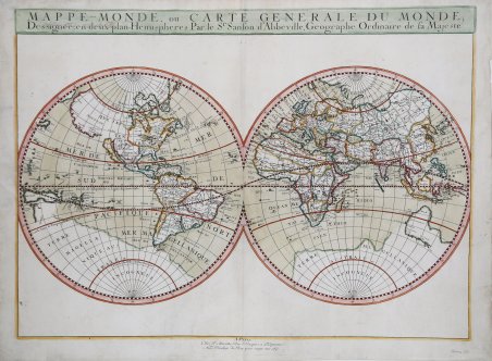
Descrizione
Carta del mondo, suddivisa nei due emisferi, ' compilata dal geografo francese Nicolas Sanson. A differenza delle precedenti mappe olandesi, quella di Sanson si concentra sulle informazioni geografiche e idrografiche, tralasciando completamente ogni aspetto decorativo; lo spazio attorno ai due emisferi viene lasciato intenzionalmente vuoto.La mappa è tratta dall'edizione del Cartes Gènerales de toutes les parties du Monde curata da Pierre Mariette, edita nel 1663. Nicolas Sanson, il più famoso cartografo francese della storia moderna, fu cosmografo al servizio di Luigi XIV, re di Francia; dotò le sue mappe delle più recenti informazioni geografiche e delle incisioni più belle e acute del periodo. Il Cartes Generales de Toutes les Parties du Monde rappresenta il più importante prodotto della cartografia commerciale francese del diciassettesimo secolo.Le mappe furono compilate a partire dal 1630 e l'atlante edito per la prima volta nel 1654, stampato da Pierre Mariette. Incisione in rame, finemente colorato a mano, in ottimo stato di conservazione. Sanson's map of the world. Unlike the earlier Dutch maps, Sanson's map focuses on the geographic and hydrographic information, the space around the double hemispheres left intentionally blank. The outline of the continents and the illustrations of interior information is very accurate for the day. For instance, this map shows all five Great Lakes, a feature shown for the first time by Sanson. However, Sanson was not immune to the cartographic myths of his day. The map shows a strange outline of a great southern continent, as well as several reflections of early knowledge of Australia, an interesting combination of old, mistaken beliefs and data from early explorations in the southern seas. Sanson also shows a large, mythical land of Jesso, El Dorado's Lake Parima in South America, and most interestingly, California depicted as an island. In Sanson's world map, made at a time when cartographers were first developing a scientific picture of the world, we can see the overlap of the old and new world views by the dominant mapmaker of his day.Map taken from Cartes Gènerales de toutes les parties du Monde by Sanson.The maps were compiled by Nicolas Sanson who published his atlas in 1654, with 100 maps, and printed by Pierre Mariette; they were issued progressively from 1630. Sanson was the most noted French cartographer in modern history. Mapmaker to Louis XIV, King of France, Sanson endowed his maps with the most recent geographical information as well as the finest and sharpest engraving of the period. His Cartes Generales de Toutes les Parties du Monde was the most important single product of French commercial cartography of the seventeenth century.Copperplate, with fine later hand colour, very good condition. Cfr. R. W. Shirley, "The Mapping of the world", 390

 Scopri come utilizzare
 Scopri come utilizzare