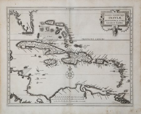
La carta si estende dalla Florida, qui chiamata Cabo de la Florida, alle Bahamas fino a Trinidad ed è impreziosita da un cartiglio con titolo drappeggiato da ghirlande e da una rosa dei venti. La carta dei Caraibi di Gerritsz servì da modello per altri cartografi per tutto il resto del secolo. Hessel Gerritsz fu intimamente coinvolto nell'espansione olandese nelle Americhe all'inizio del XVII secolo. Era il cartografo ufficiale della Compagnia olandese delle Indie orientali e quindi era a conoscenza delle ultime informazioni cartografiche che arrivavano in Olanda. Viaggiò nel Nuovo Mondo per raccogliere molte delle informazioni utilizzate per produrre le mappe in collaborazione con Johannes de Laet, uno dei direttori della Compagnia olandese delle Indie occidentali, anch'egli coinvolto negli sforzi coloniali olandesi. La mappa di De Laet apparve nella sua opera fondamentale sull'America, che è ampiamente considerata come il più importante e influente trattato sull'argomento pubblicato nel XVII secolo, il celebre Novus Orbis seu descriptionis Indiae occidentalis Libri XVIII stampato a Lugduni Batavorum: Elzevir, 1633. ' Terza edizione di una delle più importanti collezioni di viaggi nel Nuovo Mondo del diciassettesimo secolo, compilata dal direttore della neonata Compagnia Olandese delle Indie Occidentali, Johannes de Laet (1581-1649). Le edizioni precedenti furono pubblicate: la prima ad Anversa in olandese (1625), la seconda edizione – la prima in latino - a Leida, nel 1630, sempre dall’editore Elzevir. L’edizione del 1633 include per la prima volta quattro mappe regionali americane: "Americae sive Indiae Occidentalis", la migliore delineazione della costa occidentale che raffigura la California come una penisola e non un'isola, e fermandosi alla controversa regione del Passaggio a Nord Ovest; "Nova Francia et Regiones Adiacentes", una delle mappe di riferimento del Canada, la prima mappa stampata ad includere una rappresentazione accurata dell'Isola del Principe Edoardo, e la prima con il lago Champlain orientato a nord-sud, su di essa si basarono ancora Blaeu nel 1662 e Coronelli negli anni 1690; "Nova Anglia" è “di estrema importanza essendo la prima mappa a stampa a riportare i tonomi "Manbattes" (Manhattan), e "N. Amsterdam", o New York, fondata nel 1626. È anche la prima ad usare i nomi olandesi di "Noordt Rivier" e "Zuyd Rivier", rispettivamente per i fiumi Hudson e Delaware, così come l'indiano "Massachusetts", per la nuova colonia inglese” (Burden); ' "Florida, et regions vicinae" una mappa in gran parte derivata con una modifica notevole nel "posizionamento di "C. Francois" più a est nell'Oceano Atlantico. La Florida, come la conosciamo oggi, è qui chiamata "Tegesta Provinc." Questo nome, applicato qui per la prima volta, è quello di una tribù di indiani che vive sulla costa sud-ovest. "Florida" era a questo tempo applicato ad una regione molto più grande" (Burden). Bella impressione, in eccellente stato di conservazione. The map covers from Florida, here called ' Cabo de la Florida, and the Bahamas through to Trinidad and is embellished with a garland draped title cartouche and a compass rose. Gerritsz' map of the Caribbean served as a model for other cartographers throughout the rest of the century. Hessel Gerritsz was intimately involved with Dutch expansion into the Americas at the beginning of the seventeenth century. He was the official cartographer of the Dutch East India Company and thus was privy to the latest cartographic information coming into Holland. He traveled to the New World to gather much of the information used to produce maps in collaboration with Johannes de Laet, one of the directors of the Dutch West India Company, who was also involved with Dutch colonial efforts. De Laet's map appeared in his seminal work on America, which is widely regarded as the most important and influential treatise on the subject published in the 17th Century, the Novus Orbis seu descriptionis Indiae occidentalis Libri XVIII printed in Lugduni Batavorum: Elzevir, 1633. Third edition of one of the most important of seventeenth-century New World voyages collections, compiled by a director of the recently formed Dutch West India Company, Johannes de Laet (1581-1649). Previous editions were published: the first in Antwerp in Dutch (1625), the second edition-the first in Latin-in Leiden, in 1630, also by the publisher Elzevir. This issue include for the first time four American regional maps: "Americae sive Indiae Occidentalis", the best West Coast delineation to date, and interestingly depicting California as a peninsula not an island, and stopping short of the controversial region of the North West Passage; "Nova Francia et Regiones Adiacentes", one of the foundation maps of Canada, the first printed map to include an accurate depiction of Prince Edward Island, and the earliest of a north-south oriented Lake Champlain, and still relied upon by Blaeu in 1662 and Coronelli in the 1690s; "Nova Anglia" is of "extreme importance being the first printed one to use the names "Manbattes" (Manhattan), and "N. Amsterdam", or New York, founded in 1626. It is also the earliest to use the Dutch names of "Noordt Rivier" and "Zuyd Rivier", for the Hudson and Delaware Rivers respectively, as well as the Indian "Massachusetts", for the new English colony" (Burden); and "Florida, et regions vicinae" a largely derivative map with one notable alteration in the "placing of "C.Francois" further east into the Atlantic Ocean. Florida, as we know it today, is here called "Tegesta Provinc." This name, applied here for the first time, is that of a tribe of Indians living on the south-west coast. "Florida" was at this time applied to a far larger region" (Burden). ' A fine impression, on contemporary laid paper, very good condition. Cfr.

 Scopri come utilizzare
 Scopri come utilizzare