Dettagli
Anno di pubblicazione
1538
Incisori
Münster Sebastian
Descrizione
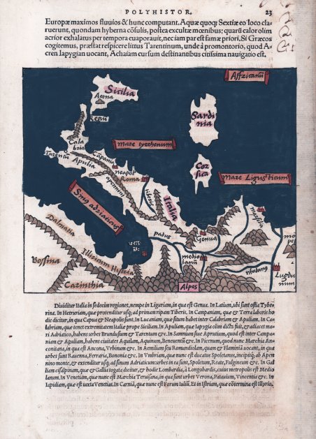
Carta geografica della penisola, con insolita orientazione con il sud in alto, tratta dal libro dello storico romano Caius Iulius Solinus ' Polyhistor, rervm toto orbe memorabilum…" edito a Basilea da Heinrich Petri nel 1538. Il ' Polyhistor ' di Solinus è una raccolta di racconti geografici a cura di Sebastian Münster. Solino era un leggendario geografo romano, grammatico e antologo. Il suo ' Polyhistor ' incorporava gran parte della storia naturale di Plinio e includeva la geografia di Pomponio Mela. Ci sono brevi osservazioni su un certo numero di domande storiche, sociali, religiose e sulla storia naturale. Il ' Polyhistor ' fu emesso per la prima volta a metà del terzo secolo. L’opera è illustrata da 18 carte geografiche, attribuite al Münster, ' ' che curò il testo del libro. Silografia, finemente colorata a mano, margine destro restaurato, per il resto in ottimo stato di conservazione. Map of Italy taken from ' Polyhistor Rerum Toto Urbe Memorabilum by ' Caius Iulius Solinus Polyhistor, printed in Basile by Henri Petri inl 1538. Solinus's ' Polyhistor ' is a collection of geographical accounts edited by Sebastian Münster. This work is renowned for its inclusion of a printed map bearing the earliest representation of the northwest coast of America as "Terra incognita" in the upper right-hand corner of the folding map of "Asia Major," the first complete map of Asia. This same map also shows one of the earliest depictions of a strait between Asia and America, nearly 200 years before Vitus Bering famously voyaged to this part of the world. At the time of publication, scholars and voyagers were still debating the plausibility of a land mass connection between the Asian and American continents. The ' Polyhistor ' also includes a second, detailed folding map of the Greek Isles and parts of modern day Turkey and Eastern Europe. Solinus was a legendary Roman geographer, grammarian and anthologist. His ' Polyhistor ' incorporated much of Pliny s Natural History and included Pomponius Mela s geography. There are brief remarks on a number of historical, social, religious and natural history questions. The ' Polyhistor ' was first issued in the middle of the third century. Münster, the editor of the 1538 and 1543 editions of the ' Polyhistor, is quite a significant figure in the history of sixteenth-century cartography. The work has been illustrated with 18 maps, ascribed to Muenster, who wrote the text of the book. Woodcut with fine later hand colour, new margin added at the right edge, otherwise very good condition. Cfr.

Scopri come utilizzare
Scopri come utilizzare

