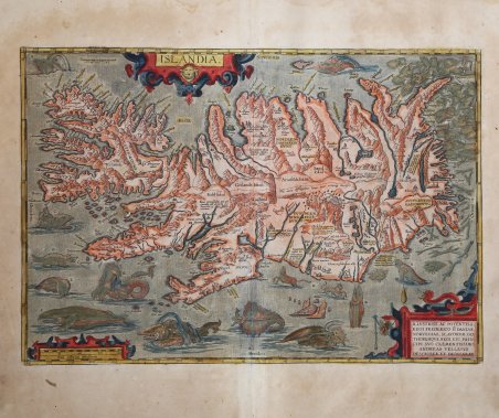
Titolo: ISLANDIA. In alto a sinistra: "Priuilegio Imp. et Belgico decennali | A. Ortel. excud. 1585". Nel cartiglio in basso a destra: ILLVSTRISS. AC POTENTISS. | REGI FREDERICO II DANIAE, NORVEGIAE, SLAVORVM, GO:|THORVMQVE REGI, ECC. PRIN:|CIPI SVO CLEMENTISSIMO, | ANDREAS VELLEIVS | DESCRIBEB. ET DEDICABAT. Bell'esemplare della classica carta dell'Islanda di Ortelius, una delle mappe più decorative mai stampate e la prima carta accurata dell'Islanda da fonti indigene. La carta raffigura l'isola in modo estremamente dettagliato, comprese le sue montagne, i fiordi e i ghiacciai, e contiene una rappresentazione grafica del monte Hekla che erutta in un'esplosione di fiamme e lava. Lungo una parte della costa, si possono vedere gli orsi polari che galleggiano sugli iceberg. La mappa include più di 200 nomi di luoghi, principalmente di origine danese, molti dei quali probabilmente sono stati letti in modo errato rispetto alla fonte originale, a causa del diverso stile di scrittura utilizzato in Islanda durante il periodo. Pur essendo tutt'altro che accurata, la mappa raffigura per la prima volta una rappresentazione significativa di tutti gli insediamenti conosciuti in Islanda e di molti altri punti di interesse, tra cui alcuni ghiacciai. Contiene, inoltre, una notevole serie di mostri e creature marine leggendarie e mitiche del XV e XVI secolo, insieme alle prime rappresentazioni del cavallo marino, della manta, del tricheco e della balena. Alcune delle immagini più fantasiose potrebbero derivare dai racconti di San Brendan, un missionario irlandese del VI secolo che, secondo la leggenda, viaggiò in Islanda e il cui nome è associato all'omonima isola mitica. Altri sono riconducibili alla Carta Marina di Olaus Magnus del 1539, anche se, probabilmente, sono derivati direttamente dalla carta delle creature marine e terrestri che appare nella Cosmographia di Sebastian Munster. La carta è stata redatta e dedicata da Andreas Velleius all'illustre e potente Federico II, Re dei danesi, dei norvegesi, degli slavi, dei goti ecc. Andreas Sorensen Vedel (1542-1616, lat. Velleius) fu un importante storico danese dell'epoca che preparò, ma a quanto pare non pubblicò mai, un trattato sulla storia della Danimarca che intendeva illustrare con delle mappe. Tuttavia, è quasi certo che Vedel non fu l'autore della mappa e che si limitò a trasmetterla a Ortelius, senza citarne la fonte. La carta di Ortelius rappresenta un grande miglioramento rispetto a tutte le precedenti rappresentazioni dell'Islanda e si ritiene quindi che possa essere stata disegnata solo da un islandese; molto probabilmente si tratta di Gudbrandur Thorlaksson, vescovo di Holar, che aveva studiato matematica e astronomia a Copenaghen. È noto che Thorlaksson realizzò una mappa della regione nel 1606. Sebbene non sia sopravvissuta alcuna mappa dell'Islanda realizzata da Thorlaksson, esistono altre prove circostanziali, tra cui un elenco di chiese e fiordi disponibile probabilmente preparato da Thorlaksson, che furono quasi certamente utilizzati per preparare la mappa. Mentre il privilegio per la stampa fu concesso nel 1585, la versione di Ortelius apparve per la prima volta in un atlante nel 1587, nell'"Additamentum IV", un'appendice di 22 nuove mappe. Esemplare del secondo stato descritto da Van den Broecke, con le lettere di legenda per i mostri; tratto dalla rara edizione italiana del "Theatrum Orbis Terrarum", stampata da Johann Baptiste Vrients nel 1608. Bella impressione su carta vergata coeva bellissima colorazione originale, leggerissima macchia di umidità in alto, altrimenti in ottimo stato di conservazione. Bibliografia Campbell, Early Maps, pl. 40; Van Broeck 161; Moreland & Bannister p.93. Title: ISLANDIA. At upper left: "Priuilegio Imp. et Belgico decennali | A. Ortel. excud. 1585". In the cartouche bottom right corner: ILLVSTRISS. AC POTENTISS. | REGI FREDERICO II DANIAE, | NORVEGIAE, SLAVORVM, GO:|THORVMQVE REGI, ETC. PRIN:|CIPI SVO CLEMENTISSIMO, | ANDREAS VELLEIVS | DESCRIBEB. ET DEDICABAT. Fine example of Ortelius' classic map of Iceland, one of the most decorative atlas maps of all time and the first relatively accurate map of Iceland from indigenous sources. The map depicts Iceland in remarkable detail, including its mountains, fjords, glaciers and a graphic depiction of Mount Hekla erupting in a fiery explosion of flames and volcanic material. Along part of the coastline, Polar Bears can be seen floating on icebergs. The map includes over 200 place names, primarily Danish in origin and many of which are likely misread from the original map, owing to the different writing style employed in Iceland during the period. While the map is far from accurate, it depicts first time a meaningful depiction of all known settlements in Iceland and many other points of interest, including a number of glaciers. The map illustrates a remarkable array of the legendary and mythical sea monsters and creatures of the 15th and 16th Century, along with early depictions of the sea horse, manta ray, walrus and whale. Some of the more purely fanciful images may derive from tales of St. Brendan, a sixth century Irish missionary who, according to legend, journeyed to Iceland and whose name is associated with a mythical island of the same name. Others are traceable to Olaus Magnus's Carta Marina of 1539, although they were probably derived directly from Munster's Cosmographia of 1545 and most notably Munster's chart of the Sea and Land Creatures. The dedication in the lower right corner notes that the map is drawn up and dedicated by Andreas Velleius to the Illustrious and powerful Frederic the Second, King of the Danes, Norwegians, Slavs, Goths etc., his most merciful Majesty. Andreas Sorensen Vedel (1542-1616) was an important Danish historian of the period who prepared, but apparently never published a treatise on history of Denmarke, which he had intended to illustrate with maps. However, it is almost certain that Vedel was not the maker of the map and simply transmitted the map to Ortelius, without mentioning its source. The map is a vast improvement over all prior maps of Iceland and it is believed therefore that it could only have been drawn by an Icelander, most likely Gudbrandur Thorlaksson, Bishop of Holar, who studied mathematics and astronomy in Copenhagen. It is known that Thorlaksson made a map of the region in 1606. While no map of Iceland by Thorlaksson survives, there is other circumstantial evidence, including a list of churches and fjords which was available and perhaps prepared by Thorlakson, which were almost certainly used in preparing the map. While a privilege for the map was granted in 1585, Ortelius's version first appeared in an atlas in 1587, in the 'Additamentum IV', an appendix of 22 new maps not featured in the last full 'Theatrum Orbis Terrarum'. Example of the second state according Van den Broecke, with key letters for monsters. From the Italian edition of 'Theatrum Orbis Terrarum', printed by Johann Baptiste Vrients in 1608. A fine impressions on contemporary laid paper with full original colouring, very slight moisture stain at top, otherwise in very good condition. Bibliografia Campbell, Early Maps, pl. 40; Van Broeck 161; Moreland & Bannister p.93. Cfr.

 Scopri come utilizzare
 Scopri come utilizzare