Insulae Danicae in mare Baltico sitae utpote Zeelandia, Fionia, Langelandia, Lalandia, Falstria, Fembria Mona…
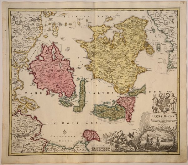
Insulae Danicae in mare Baltico sitae utpote Zeelandia, Fionia, Langelandia, Lalandia, Falstria, Fembria Mona…
Metodi di Pagamento
- PayPal
- Carta di Credito
- Bonifico Bancario
- Pubblica amministrazione
- Carta del Docente
Dettagli
- Anno di pubblicazione
- 1716
- Luogo di stampa
- Norimberga
- Formato
- 590 X 505
- Incisori
- HOMANN Johann Baptist
Descrizione
Bella e dettagliata carta geografica delle principali isole e della costa orientale della Danimarca, e parte della Svezia, che comprende la costa svedese con Helsingborg, Landskrona e Malmö, la costa danese con Helsingör e Copenaghen e l'isola di Ween con UranienburgUn elaborato cartiglio, sormontato dallo stemma reale danese, con una grande vignetta con navi che approdano nel porto di Copenaghen, affiancata da diverse sirene. La carta fu realizzata da Homann per il suo Grosser Atlas. Johann Baptist Homann è stato un geografo e cartografo tedesco; nel 1702 fondò la sua casa editrice. Homann acquisì fama come uno dei principali cartografi tedeschi, e nel 1715 fu nominato geografo imperiale dall'imperatore Carlo VI. Nello stesso anno fu anche nominato membro dell'Accademia Prussiana delle Scienze a Berlino. Nel 1716 Homann pubblicò il suo capolavoro Grosser Atlas ueber die ganze Welt. Numerose mappe furono redatte in collaborazione con l'incisore Christoph Weigel. Homann morì a Norimberga nel 1724. Gli successe suo figlio Johann Christoph (1703-1730). L'azienda continuò dopo la sua morte come azienda degli eredi Homann, gestita da Johann Michael Franz e Johann Georg Ebersberger. Dopo successivi cambiamenti nella gestione, l'azienda si sciolse nel 1852. Beautiful and detailed map of the main islands and the eastern coastline of Denmark and a little of Sweden, with the Swedish coast with Helsingborg, Landskrona and Malmö, the Danish coast with Helsingör and Copenhagen and the island of Ween with Uranienburg.An elaborate cartouche, surmounted by the Danish royal coat of arms, with a large vignette of the approach to Copenhagen with ships in the harbor, flanked by numerous mermaids. The map was made by Homann for his Grosser Atlas. Johann Baptist Homann was a German geographer and cartographer; in 1702 he founded his own publishing house. Homann acquired renown as a leading German cartographer, and in 1715 was appointed Imperial Geographer by Emperor Charles VI. In the same year he was also named a member of the Prussian Academy of Sciences in Berlin. In 1716 Homann published his masterpiece Grosser Atlas ueber die ganze Welt; numerous maps were drawn up in cooperation with the engraver Christoph Weigel the Elder. Homann died in Nuremberg in 1724 and was succeeded by his son Johann Christoph (1703-1730). The company carried on upon his death as Homann heirs company, managed by Johann Michael Franz and Johann Georg Ebersberger. After subsequent changes in management the company folded in 1852. Etching with fine original colour, good condition. Cfr.