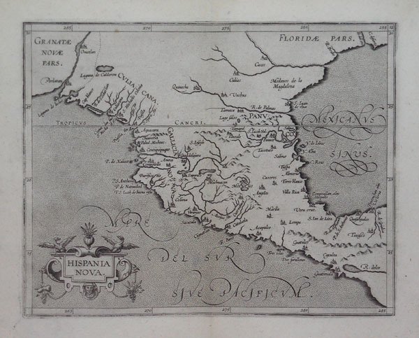
Una delle prime mappe del sud-ovest americano e del Messico, compresa la parte meridionale dell’attuale Texas, qui chiamata floridae Pars, con il Rio Grande, indicato come R. de Palmas. Magnifica carta geografica, tratta dall'opera Descriptionis Ptolemaicae Augmentum (Louvain, 1597), il primo atlante dedicato esclusivamente al Nuovo Mondo, e anche l'unico lavoro che si conosca di Cornelis Wytfliet. L'atlante fu così intitolato proprio perché era inteso come complemento della Geografia di Tolomeo che, naturalmente, non poteva comprendeva regioni che sarebbero state scoperte solo diversi secoli dopo. L'atlante di Wytfliet comprendeva 19 mappe: una mappa del mondo e 18 carte regionali, che costituiscono le prime, o tra le prime, mappe realizzate di specifiche aree del Nord e del Sud America. Le mappe sono accompagnate da testo, in cui vengono fornite nozioni di geografia, storia, etnografia, nonché una storia dell'esplorazioni e dei viaggi di C. Colombo (1492-1502), John Cabot (1497-98), Sebastiano Caboto (1526-28), Francisco Pizarro (1527-35) ecc. L'opera fu pubblicata in diverse edizioni, l'ultima delle quali a Arnhem, dove, nel 1615, Jan Janssonius curò la versione col il testo in francese. Bulino, con pieni margini, in buone condizioni. Bibliografia Koeman, Atlantes Neerlandici (Wytfliet 1A), III, p. 219. Nordenskiöld 307. Wagner, Cartography of the Northwest Coast 190. One of the earliest maps of the American Southwest and Mexico, including the southern part of present-day Texas. Texas was then little known, and that is reflected in the paucity of information on this map, where the borderlands region is labeled Floridæ Pars and Medanos de la Magdalena. The rivers in the Texas borderlands are Rio de las Palmas, a large, unnamed river (perhaps the Rio Grande), Rio Bravo, and Rio del Oro. An excellent early copperplate engraving from Wyfliet's Descriptionis Ptolemaicae augmentum, which was the first atlas to exclusively feature the Americas. "The only known geographic work by Wytfliet, Descriptiones Ptolemaicae Augmentum.can be described as the first separately published atlas devoted solely to the Americas. As a compiler instead of creator, his production has remained all the more valuable as an excellent summary of everything then known in the Spanish Netherlands concerning the New World. The maps in Wytfliet's Augmentum have been said to play the same part in the history of cartography of the New World as Ptolemy's maps do for the old, and they give us a valuable summary of the early cartography of America" (Martin & Martin, p. 75). Burden 105: "Published in the first atlas of America.this map concentrated on the Spanish area of influence in present-day Mexico. Like a lot of his maps, [Wytfliet's Hispania Nova] draws from Plancius' world map of 1592 amongst others. The area covered takes in all of present-day southern Texas up to the latitude of 30º north. No other states of the map are known and all issues are without text on the back." Wytfliet's atlas with nineteen maps relating to America was republished in 1598, 1603, 1605, 1607, 1611, and 1615, with no changes to the present map. Copperplate, full margins, good conditions. Bibliografia Koeman, Atlantes Neerlandici (Wytfliet 1A), III, p. 219. Nordenskiöld 307. Wagner, Cartography of the Northwest Coast 190. ' Cfr. Burden, The Mapping of North America, 105

 Scopri come utilizzare
 Scopri come utilizzare