Dettagli
Anno di pubblicazione
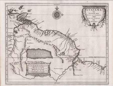
1630
Incisori
Laet Johannes de
Descrizione
La carta ricopre una parte della costa sudamericana dall'isola di Trinidad fino a poco oltre la foce del Rio delle Amazzoni, tra gli attuali Paesi del Venezuela e del Brasile. I toponimi sono relegati a vari elementi geografici, villaggi indigeni e avamposti costieri europei, mentre la topografia è rappresentata in modo pittorico. La mappa fu pubblicata a Leida nel 1630 come parte della Nieuwe Wereldt often Beschrijvinghe van West-Indien (Descrizione delle Indie Occidentali) di Johannes de Laet. L'opera era stata pubblicata originariamente nel 1625 e conteneva dieci mappe; questa è la versione leggermente aggiornata che conteneva quattordici mappe e 100 pagine di testo in più, a testimonianza del crescente interesse degli olandesi per il Nuovo Mondo. Descritte da Philip Burden come "probabilmente la più bella descrizione delle Americhe pubblicata durante il XVII secolo", le mappe dell'opera di de Laet si basavano direttamente sulla cartografia di Hessel Gerritsz, apprendista incisore presso W. J. Blaeu prima di avviare una propria attività. Fu poi nominato cartografo della Compagnia olandese delle Indie orientali e successivamente ricoprì la stessa posizione nella neonata Compagnia delle Indie occidentali. Sebbene Gerritsz abbia effettivamente visitato la zona durante il suo viaggio in Sud America e nelle Indie Occidentali intrapreso nel 1628, questa carta manca ovviamente di conoscenze di prima mano, tranne che lungo la costa. L'interno è dominato dall'enorme lago (Parime Lacus) con la leggendaria città di El Dorado (Manoa, o el Dorado) sulle sue rive. Alla fine del XVI e all'inizio del XVII secolo furono intraprese diverse spedizioni per trovare questa leggendaria città d'oro e, sebbene abbiano contribuito in modo significativo alla cartografia della regione, alla fine furono tutte infruttuose. Per la compilazione dei suoi dati geografici Johannes de Laet si avvalse di ricerche meticolose e di fonti contemporanee. In qualità di direttore della neonata Compagnia Olandese delle Indie Occidentali, durante la compilazione delle mappe si è avvalso anche delle informazioni più recenti tratte dalla corrispondenza privata, dai manoscritti e da altri segreti aziendali. Per questa mappa sembra aver acquisito informazioni dai rilevamenti inglesi dell'estuario del Rio delle Amazzoni attraverso il cartografo inglese Gabriel Tatton, che in alcuni momenti della sua carriera lavorò per gli editori olandesi. De Laet corrispondeva anche con Sir Henry Spelman, tesoriere della Compagnia inglese della Guiana. La carta è splendidamente incisa con cartigli decorativi del titolo e della scala delle distanze e una grande rosa dei venti. The map covers part of the South American coast from the island of Trinidad to just beyond the mouth of the Amazon River, between the present-day countries of Venezuela and Brazil. Place names are relegated to various geographical features, indigenous villages and European coastal outposts, while topography is pictorially depicted. The map was published in Leiden in 1630 as part of Johannes de Laet's Nieuwe Wereldt often Beschrijvinghe van West-Indien (Description of the West Indies ). The work was originally published in 1625 and contained ten maps; this is the slightly updated version that contained fourteen maps and 100 more pages of text, reflecting the growing interest of the Dutch in the New World. Described by Philip Burden as "probably the finest description of the Americas published during the seventeenth century," the maps in de Laet's work were based directly on the cartography of Hessel Gerritsz, an engraver's apprentice to W. J. Blaeu before starting his own business. He was then appointed cartographer to the Dutch East India Company and later held the same position in the newly formed West India Company. Although Gerritsz actually visited the area during his trip to South America and the West Indies undertaken in 1628, this map obviously lacks first-hand knowledge, except along the coast. The interior is dominated by the huge lake (Parime Lacus) with the legendary city of El Dorado (Manoa, or el Dorado) on its shores. Several expeditions were undertaken in the late 16th and early 17th centuries to find this legendary city of gold, and although they contributed significantly to the mapping of the region, they were all ultimately unsuccessful. Johannes de Laet used meticulous research and contemporary sources to compile his geographical data. As director of the newly formed Dutch West India Company, he also made use of the latest information from private correspondence, manuscripts, and other company secrets when compiling the maps. For this map he appears to have acquired information from English surveys of the Amazon estuary through the English cartographer Gabriel Tatton, who at times during his career worked for Dutch publishers. De Laet also corresponded with Sir Henry Spelman, treasurer of the English Guiana Company. The map is beautifully engraved with decorative cartouches of the title and distance scale and a large compass rose. Cfr.

 Scopri come utilizzare
 Scopri come utilizzare