France revised and augmented, the attire of the French and situations of their cheifest cyties…
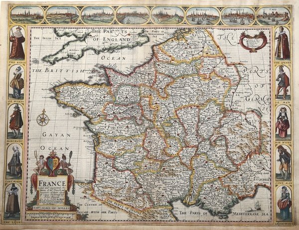
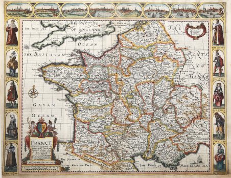
France revised and augmented, the attire of the French and situations of their cheifest cyties…
Metodi di Pagamento
- PayPal
- Carta di Credito
- Bonifico Bancario
- Pubblica amministrazione
- Carta del Docente
Dettagli
- Anno di pubblicazione
- 1676
- Luogo di stampa
- Londra
- Formato
- 525 X 410
- Incisori
- SPEED John
Descrizione
Decorativa carte-a-figures della Francia, pubblicata nell'atlante di John Speed "A Prospect of the most famous part of the World" - edizione del 1676 con l'imprint di Roger Rea.Dieci figure decorano i due margini laterali, e mostrano, tra gli altri, il re, la regina, un commerciante, un avvocato. Nel margine superiore corrono le vedute di otto città, tra cui Parigi, Orleans e Bordeaux.Incisione su rame, finemente colorata a mano, in ottimo stato di conservazione. Al verso, descrizione della Francia in lingua inglese. Beautiful carte-a-figures map covers France and displays the various regions, published in A Prospect of the most famous part of the World" - edition of 1676, with Roger Rea's imprint.The map includes a decorative title cartouche and a key explaining the symbols used to identify various cities and towns. It is decorated across the top with views of eight cities, Angers, Poitiers, Orleans, Paris, Rouen, La Rochelle, Bordeaux and Calais. The panels down both sides depict pairs of men and women of the region in period dress. A description of France in English appears verso.Copper engraving, hand coloured, in very good condition. Cfr.