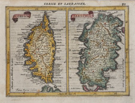
Corsica & Sardinia
Corsica & Sardinia | Stampe | HONDIUS Jodocus


Corsica & Sardinia
Corsica & Sardinia | Stampe | HONDIUS Jodocus
Metodi di Pagamento
- PayPal
- Carta di Credito
- Bonifico Bancario
- Pubblica amministrazione
- Carta del Docente
Dettagli
- Anno di pubblicazione
- 1607
- Luogo di stampa
- Amsterdam
- Formato
- 195 X 140
- Incisori
- HONDIUS Jodocus
Descrizione
Mappa tratta dall’Atlas minor Gerardi Mercatoris a I. Hondio plurimis aeneis tabulis auctus et illustratus. Apparso per la prima volta nel 1607, l'atlante Mercator-Hondius-Mercator fu un successo a livello europeo, con edizioni pubblicate sia in latino che in diverse altre lingue. Le varie edizioni furono curate da Jodocus Hondius e poi da Jan Janssonius, e contenevano un numero crescente di mappe. "Shortly after the publication of the big folio-atlases the need was apparantly felt for a smaller-sized atlas, one that would be handier, and, above all, cheaper, so that a larger public might have access to the use of maps. The publication of the ' Atlas Minor ' appeared to be a great success for Hondius; the first Latin edition was in great demand. The copperplates of the first atlases minor were most almost certainly engraved by Jodocus Hondius himself. After 1621, the copperplates of the ' Atlas Minor ' were sold to a London editor. Firstly, they appeared in ' Purchas his Pilgrinies, printed in 1625 by William Stansby for Henry Featherstone. Next they were used for the translation of the Mercator-atlas, printed in small folio under the title ' Historia mundi, or Mercators atlas, ' by Thomas Cotes for Michael Sparke and Samuel Cartwight in 1635". (cf. Koeman II Me 191). "As with the ' Theatrum ' of Abraham Ortelius, Jodocus Hondius planned a reduced size version of Gerard Mercator's folio atlas. Just one year after his first edition he published his Latin text ' Atlas Minor ' in collaboration with Jan Jansz. and Cormelis Claesz. The arrangement between these three is not understood clearly but Hondius is believed to have been the owner of the copperplates. Cartographically this is taken directly from the folio maps by Hondius in 1606 [.]. with the inevitable loss of detail due to the reduction” (cf. Burden, The Mapping of North America, 153). ' Incisione su rame, finemente colorata a mano, in buone condizioni. Bibliografia Koeman II Me 191; cfr. Phillips 426; cfr. Burden 153. Map taken from ' Atlas minor Gerardi Mercatoris a I. Hondio plurimis aeneis tabulis auctus et illustratus. Appearing first in 1607, the Hondius-Mercator ‘smaller’ atlas was a Europe-wide success, with editions published both in Latin and in several vernaculars. The various editions were edited by Jodocus Hondius and then Jan Janssonius, and contained an increasing number of maps. "Shortly after the publication of the big folio-atlases the need was apparantly felt for a smaller-sized atlas, one that would be handier, and, above all, cheaper, so that a larger public might have access to the use of maps. The publication of the ' Atlas Minor ' appeared to be a great success for Hondius; the first Latin edition was in great demand. The copperplates of the first atlases minor were most almost certainly engraved by Jodocus Hondius himself. After 1621, the copperplates of the ' Atlas Minor ' were sold to a London editor. Firstly, they appeared in ' Purchas his Pilgrinies, printed in 1625 by William Stansby for Henry Featherstone. Next they were used for the translation of the Mercator-atlas, printed in small folio under the title ' Historia mundi, or Mercators atlas, ' by Thomas Cotes for Michael Sparke and Samuel Cartwight in 1635". (cf. Koeman II Me 191). "As with the ' Theatrum ' of Abraham Ortelius, Jodocus Hondius planned a reduced size version of Gerard Mercator's folio atlas. Just one year after his first edition he published his Latin text ' Atlas Minor ' in collaboration with Jan Jansz. and Cormelis Claesz. The arrangement between these three is not understood clearly but Hondius is believed to have been the owner of the copperplates. Cartographically this is taken directly from the folio maps by Hondius in 1606 [.]. with the inevitable loss of detail due to the reduction” (cf. Burden, The Mapping of North America, 153). ' Copperplate with fine colouring, good conditions. Bibliografia Koeman II Me 191; cf. Phillips 426; cf. Burden 153. ' Cfr.
