Dettagli
Anno di pubblicazione
1708
Luogo di stampa
Amsterdam
Incisori
CHATELAIN Henri Abraham
Descrizione
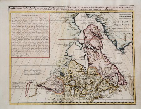
Carta inserita nell'Atlas Historique, pubblicato ad Amsterdam tra il 1705 e il 1720. L'atlante, in 7 volumi, è innovativo per la sua epoca perché combina le mappe geografiche con incisioni e informazioni di carattere geografico, storico, etnografico e araldico. La mappa di Chatelain del Canada è stata la prima mappa stampata a localizzare Detroit, rilasciata per la prima volta solo 2 anni dopo la fondazione del villaggio.L'area intorno alla Baia di Hudson è abitata da tribù native chiamate "Christinaux o Kilistinons", mentre Labrador è la sede degli "Eskimaux".La mappa presenta una serie di note che si riferiscono specificamente ai nomi degli esploratori e alle date in cui hanno scoperto determinati luoghi. Incisione in rame, finemente colorata a mano, in ottime condizioni. Henri Abraham Chatelain (1684 - 1743) era un pastore ugonotto di origini parigine. È meglio conosciuto come cartografo olandese e più specificamente per il suo contributo cartografico nell’Atlas Historique ' in sette volumi, pubblicato ad Amsterdam tra il 1705 e il 1720. Innovativo per il suo tempo, l'Atlas Historique ' combinava incisioni e opere d'arte con studi di geografia, storia, etnologia, araldica e cosmografia. Alcuni studiosi suggeriscono che l'Atlas Historique ' non fu compilato esclusivamente da Henri Chatelain, come si crede comunemente, ma piuttosto fu un'impresa familiare che coinvolse Henri, suo padre Zacharie e suo fratello, sempre Zacharie. Chatelain's map of Canada was the first printed map to locate Detroit, first issued only 2 years after the founding of the Village by Cadillac.The map is one of the most important maps of Canada printed during its time. Numerous trading posts and missions in New France and the major towns of the adjacent British colonies are shown. The area around Hudson's Bay is inhabited by native tribes referred to as the "Christinaux or Kilistinons," while Labrador is home to the "Eskimaux."The map features a number of notes specifically referring to the names of explorers and the dates in which they discovered certain places, such as the reference to 'Nouveau Danemarc', discovered by the Danish explorer, Jan Munk, in 1619. The depiction of the upper Mississippi and Ohio basins is also quite detailed. Taken from "Atlas Historique" published in Amsterdam between 1705 and 1720. ' Henri Abraham Chatelain (1684 - 1743) was a Huguenot pastor of Parisian origins. He is best known as a Dutch cartographer and more specifically for his cartographic contribution in the seminal seven volume ' Atlas Historique, published in Amsterdam between 1705 and 1720. Innovative for its time, the ' Atlas Historique ' combined fine engraving and artwork with scholarly studies of geography, history, ethnology, heraldry, and cosmography. Some scholarship suggests that the ' Atlas Historique ' was not exclusively compiled by Henri Chatelain, as is commonly believed, but rather was a family enterprise involving Henri, his father Zacharie and his brother, also Zacharie. Copperplate, fine later hand colour, in good condition. Cfr.

 Scopri come utilizzare
 Scopri come utilizzare