Barbaria
Stampe
BLAEU Johannes
1650

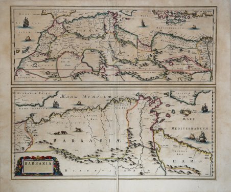
Barbaria
Stampe
BLAEU Johannes
1650
280,00 €
(Roma,
Italia)
Metodi di Pagamento
- PayPal
- Carta di Credito
- Bonifico Bancario
- Pubblica amministrazione
- Carta del Docente
Dettagli
- Anno di pubblicazione
- 1650
- Luogo di stampa
- Amsterdam
- Formato
- 590 X 500
- Incisori
- BLAEU Johannes
Descrizione
Mappa del Mediterraneo e dle Nord Africa tratta dal "Atlas Major" del Blaeu. Incisione in rame, coloritura coeva, in buone condizioni. Uncommon map of the Mediterranean coast of Africa, home to the infamous Barbary pirates. Two maps, one above the other. The top map shows the entire coast from C. Bajodor to the Nile delta and includes the Strait of Gibraltar. The bottom map depicts an enlarged area of present day Algiers, from Mare Ibericum to the island of Malta and a bit of Sicily. Several types of sailing ships and galleys, leopards and lions and a garland draped title cartouche ornament the map. Cfr.