Anchorages in the Solomon Islands
Anchorages in the Solomon Islands | Stampe | Admiralty Charts, Admiralty Charts
Anchorages in the Solomon Islands
Anchorages in the Solomon Islands | Stampe | Admiralty Charts, Admiralty Charts
Metodi di Pagamento
- PayPal
- Carta di Credito
- Bonifico Bancario
- Pubblica amministrazione
- Carta del Docente
Dettagli
- Formato
- mm 617x470
- Edizione
- '900
- Incisori
- Admiralty Charts
- Soggetto
- Salomon Islands - Pacific Ocean
- Disegnatori
- Admiralty Charts
- Lingue
- Italiano
Descrizione
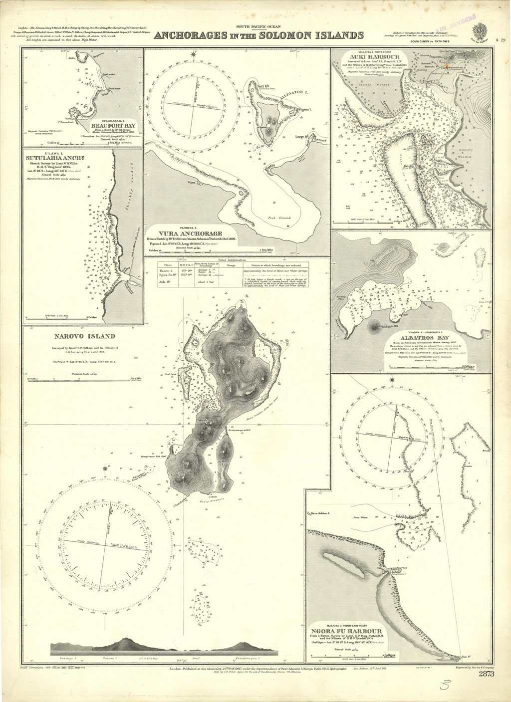
Anchorages in the Solomon Islands. In the upper left corner of the chart insert of Beaufort Bay From a Sketch by M.r T.H. Switzer Master Schooner Roderick Dhu, 1896, Sutulahia Anch.e Sketch Survey by Lieut. W.R. Willis H.M.S. "Ringdove" 1895. In the middle part of the chart insert of Vura Anchorage From a Sketch by M.r T.H. Switzer, Master, Schooner, "Roderick Dhu"1896, Narovo Island Surveyed by Lieut. C.F. Odham and the Officers of H.M. Surveying Ship "Lark" 1882. In the right part of the chart insert of Auki Harbour Surveyed by Lieut. Com. R.L. Hancock and the Officers of H.M. Surveying Vessel "Sealark" 1913, Albatros Bay From an Austrian Government Sketch Survey, 1897, Ngora Fu Harbour From a Sketch Survey by Lieut. G.P. Bigg-Wither and the Officers of H.M.S. "Pylades", 1905. London Published at the Admiralty 20th Feb. 1907, under the Superintendence of Rear Admiral A. Mostyn Field, Hydrographer.Small corrections: 1927. Autore: Admiralty Charts. Luogo: Salomon Islands - Pacific Ocean. Anno: '900. Tecnica: incisione. Dimensioni: 617x470 mm
Anno di pubblicazione: '900
