A View on the Grand Canal of Venice shewing the Convento of St. Clare.
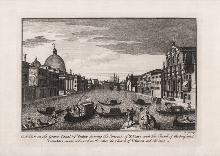
A View on the Grand Canal of Venice shewing the Convento of St. Clare.
Metodi di Pagamento
- PayPal
- Carta di Credito
- Bonifico Bancario
- Pubblica amministrazione
- Carta del Docente
Dettagli
- Anno di pubblicazione
- 1760
- Luogo di stampa
- Londra
- Formato
- 240 X 180
- Incisori
- BARROW John
Descrizione
Veduta di Venezia tratta dal celebre A New Geographical Dictionary: Containing a Full and Accurate Account of the Several Parts of the Known World, as it is Divided Into Continents, Islands, Oceans, Seas, Rivers, Lakes, &c. : the Situation, Extent, and Boundaries, of All the Empires, Kingdoms, States, Provinces &c. in Europe, Asia, Africa, and America . : Together with the Religion, Learning, Policy, Manners, and Customs, of the Inhabitants : to which is Prefixed, an Introductory Dissertation, Explaining the Figure and Motion of the Earth . : Illustrated with a New and Accurate Set of Maps of All the Parts of the Known World, Making a Compleat Atlas, the Dresses of the Inhabitants, and a Great Variety of Plans and Perspective Views of the Principal Cities, Towns, Harbours, Structures, Ruins, and Other Places of Antiquity di John Barrow, stampato a ' Londra nel 1760. Acquaforte, impressa su carta vergata coeva, con margini, in perfetto stato di conservazione. View of Venice from the A New Geographical Dictionary: Containing a Full and Accurate Account of the Several Parts of the Known World, as it is Divided Into Continents, Islands, Oceans, Seas, Rivers, Lakes, &c. : the Situation, Extent, and Boundaries, of All the Empires, Kingdoms, States, Provinces &c. in Europe, Asia, Africa, and America . : Together with the Religion, Learning, Policy, Manners, and Customs, of the Inhabitants : to which is Prefixed, an Introductory Dissertation, Explaining the Figure and Motion of the Earth . : Illustrated with a New and Accurate Set of Maps of All the Parts of the Known World, Making a Compleat Atlas, the Dresses of the Inhabitants, and a Great Variety of Plans and Perspective Views of the Principal Cities, Towns, Harbours, Structures, Ruins, and Other Places of Antiquity by John Barrow, printed in London, 1760. Etching, with margins, very good condition. Cfr.