Ordnance Survey Road Map of North Devon. Sheet 31. Scale: Half-Inch to One Mile. BRIGHT, CLEAN COPY
Ordnance Survey Road Map of North Devon. Sheet 31. Scale: Half-Inch to One Mile. BRIGHT, CLEAN COPY | Libri antichi e moderni | Ordnance Survey
Libri antichi e moderni
Ordnance Survey
Ordnance Survey, Southampton,
1937
20,70 €
(Devon,
Regno Unito)
Metodi di Pagamento
- PayPal
- Carta di Credito
- Bonifico Bancario
- Pubblica amministrazione
- Carta del Docente
Dettagli
- Anno di pubblicazione
- 1937
- Autore
- Ordnance Survey
- Editori
- Ordnance Survey, Southampton
- Soggetto
- topography, cartography, maps, ordnance survey, devon, devonshire, north devon, ellis martin
- Lingue
- Inglese
Descrizione
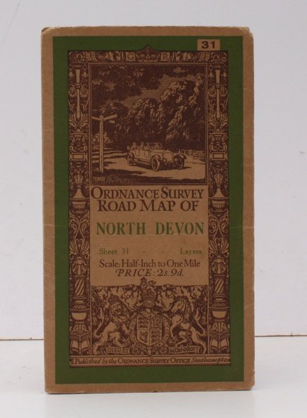
Folding coloured map on cloth measuring 29.5 x 22 ins (approx. 65 x 56 cms) folding in 21 panels to 7.5 x 4.5 ins (approx. 19 x 12 cms), a few contemporary annotations in ink in a neat hand; original pictorial card wrappers, a very good, bright, clean copy. The Half-Inch series began in 1919; this is a 1920s reissue. The cover is Ellis Martin's 'car passing signpost' in green and brown. Browne, 12.2.a
