Ordnance Survey Road Map of Carlisle. Sheet 2. Layers. Scale: Half-Inch to One Mile. BRIGHT, CLEAN COPY OF THE 1929 ISSUE
Ordnance Survey Road Map of Carlisle. Sheet 2. Layers. Scale: Half-Inch to One Mile. BRIGHT, CLEAN COPY OF THE 1929 ISSUE | Libri antichi e moderni | Ordnance Survey
Libri antichi e moderni
Ordnance Survey
Ordnance Survey, Southampton,
1929
29,90 €
(Devon,
Regno Unito)
Metodi di Pagamento
- PayPal
- Carta di Credito
- Bonifico Bancario
- Pubblica amministrazione
- Carta del Docente
Dettagli
- Anno di pubblicazione
- 1929
- Autore
- Ordnance Survey
- Editori
- Ordnance Survey, Southampton
- Soggetto
- topography, cartography, maps, ordnance survey, carlisle
- Lingue
- Inglese
Descrizione
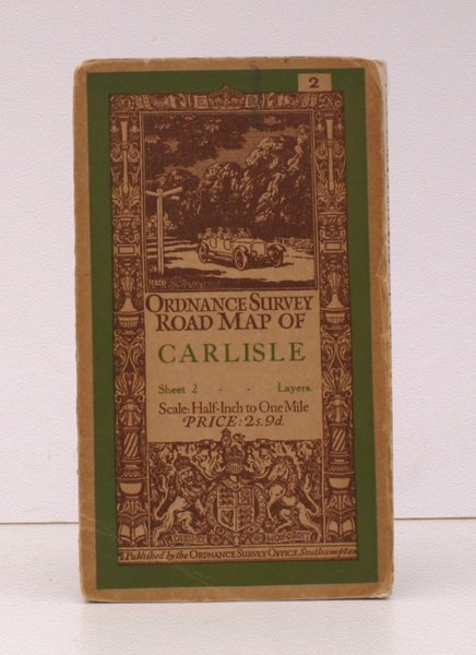
Folding coloured map on cloth measuring 22 x 30 ins (approx. 56 x 76 cms) folding in 21 panels to 7.0 x 4.0 ins (approx. 17.7 x 10.1 cms); original pictorial card wrappers, neat stamp on rear wrapper, a very good, bright, clean copy The Half-Inch Layered series with striking 'car and signpost' cover by Ellis Martin was first issued in in 1913; Sheet 2 was first published in that year. The cover is 'car and signpost' in green and brown with green sheet name. This is the 1929 revision. SCARCE IN THIS CONDITION. Browne, 12.2a.
